HALIFAX — For residents of Canada's East Coast, some of the latest images showing the potential path northward for hurricane Lee are disturbing.
By combining multiple computer-generated forecasts, meteorologists have produced maps of the western Atlantic Ocean that suggest the powerful storm could slam into the Maritimes late next week.
But Chris Fogarty, program manager at the Canadian Hurricane Centre in Halifax, says these long-range models are of little value at this stage.
Fogarty says these spaghetti models — so called because the layers of predicted tracks look like splayed noodles — don't adequately represent the broad range of possible forecasts.
"In the case of Lee, these maps are not very useful beyond about five days because the noodles can become very scattered and confusing," he said Friday in an email.
"Beyond about five days — depending on the degree of chaos in the atmosphere — they can appear more focused than they should be. At those long time ranges, they don't usually depict the (full) range of possible tracks."
As an example, Fogarty pointed to the path recently taken by hurricane Franklin earlier this month.
The 10-day spaghetti model for Franklin also indicated it would head toward Atlantic Canada, but its actual track took the storm out to sea long before it came close to Canadian waters.
"The plots for Franklin showed numerous track possibilities, but the actual track occurred outside many of the predictions," Fogarty said. "So that was an example of how they can be misleading."
Earlier in the week, the hurricane centre posted an image on social media showing the difference between the 10-day prediction and Franklin's actual track, saying it provided "a stark reminder of the considerable uncertainties in model track predictions."
Fogarty said the centre uses spaghetti models in its computer analysis, but the models are not displayed on Environment Canada's website. "We don't display them in our tweets either," he said, adding that the diagrams "can confuse the lay viewer."
The Canadian Hurricane Centre produces its own online hurricane track map, which provides a five-day forecast.
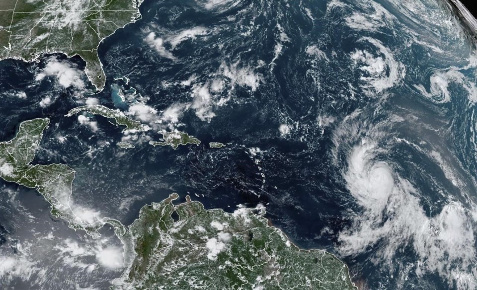
As Lee churned through the northeast Caribbean on Friday, it became the first Category 5 storm of the hurricane season before it lost some of its strength and was downgraded to Category 4 with sustained winds reaching 250 kilometres per hour.
Category 5 hurricanes produce devastating winds in excess of 252 kilometres per hour, while Category 4 storms generate winds reaching at least 209 kilometres per hour, which can also cause catastrophic damage to buildings and trees.
The National Hurricane Center in Miami issued a public advisory Friday saying Lee would remain a powerful hurricane into next week as it passes north of the Virgin Islands and Puerto Rico.
"Some fluctuations in intensity are likely over the next few days," the American agency said. "Hurricane-force winds extend outward up to (55 kilometres) from the centre and tropical-storm-force winds extend outward up to (220 kilometres)."
Large swells generated by Lee were expected to reach the British and U.S. Virgin Islands, Puerto Rico, Haiti and the Dominican Republic, the Turks and Caicos Islands, the Bahamas and Bermuda this weekend.
"Dangerous surf and rip currents are expected to begin along most of the U.S. East Coast beginning Sunday," the advisory said.
Lee is the 12th named storm of the Atlantic hurricane season, which runs from June 1 to Nov. 30 and typically peaks in September.
"It is way too soon to know what level of impacts, if any, Lee might have along the U.S. East Coast, Atlantic Canada or Bermuda late next week," the U.S.-based hurricane centre said.
Meanwhile, tropical storm Margot became the 13th named storm after forming Thursday evening well east of Lee. Margot was forecast to strengthen into a hurricane over the weekend but was expected to remain far from Canada and the United States.
This report by The Canadian Press was first published Aug. 8, 2023.
— With files from The Associated Press
Michael MacDonald, The Canadian Press