An Environment Canada snowsquall warning continues this morning for Searchmont - Montreal River Harbour - Batchawana Bay - Agawa - Lake Superior Park.
Last night's warnings for Wawa and Pukaskwa Park have been cancelled.
Across the St. Mary's River, the U.S. National Weather Service has no comparable snow warnings in effect.
However, U.S. weather officials advise that signifcant snow acumulations are possible this coming week, from Thursday into next weekend, in the snowbelt regions of the Eastern Upper Peninsula and the northern part of the Lower Peninsula.
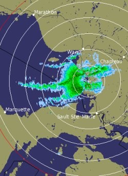
The radar image whown was created at 7:40 a.m. Sunday.
************************* Snowsquall warning continued
Flurries and local snow squalls to the lee of Lake Superior today.
This is a warning that snowsqualls are imminent or occurring in these regions.
Monitor weather conditions. Listen for updated statements.
Cold westerly winds continue to generate flurries and local snow squalls to the Lee of Lake Superior.
Snow squalls will affect Highway 17 from Batchawana Bay to Lake Superior park until later this afternoon when they should begin to move south of the area as a cold front moves across the region.
Local accumulations of 10 to 15 centimetres are possible today.
Brisk westerly winds up to 50 km/h will produce local blowing and drifting snow as well.
Caution is advised as travel will be hazardous along Highway 17 due to poor visibilities in falling and blowing snow.
*************************