The following storm warning was issued this morning by Environment Canada for Wawa - Pukaskwa Park - White River - Dubreuilville.
************************* Major winter storm ending Monday morning.
This is a warning that dangerous winter weather conditions are imminent or occurring in these regions.
Monitor weather conditions. Listen for updated statements.
A major winter storm currently over Minnesota will move towards Lake Superior by this evening.
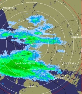
Snow has begun across Superior west and northeast of Lake Superior.
The snow will spread across the warning areas today with the heaviest bands of snow giving significant accumulations tonight.
Most regions will see 15 to 25 centimetres of snow by Monday morning.
Regions along the western and northern shores of Lake Superior will see locally higher amounts since they will be closer to the centre of the storm.
This storm will be accompanied by strong winds which will whip around the freshly fallen snow and cause areas of blowing snow reducing visibility at times.
Cold northeast or north winds with gusts to 50 km/h will continue to produce cold wind chill values near minus 40 particularly over northwestern Ontario where a wind chill warning is in effect for Red Lake and Kenora. The frigid wind chill conditions are spreading eastward to Sioux Lookout and Dryden.
Both Sioux Lookout and Dryden will still see snowfall up to 15 centimetres by Monday morning but since the heaviest snowband will be to the east of them the winter storm warning has now been changed to a wind chill warning.
Kapuskasing and Timmins will receive slightly lesser snow amounts than their neighbours to the west.
Furthermore the wind chill values will not be as cold since they will escape the brunt of the frigid Arctic air which will sweep in behind the storm.
This is the reason they are under a snowfall warning instead of a winter storm warning.
This storm will make travel difficult and dangerous due to the snowfall amount - reduced visibilities in blowing snow and cold wind chill values for over 24 hours in some locations.
*************************