The following snowfall warning has been issued by Environment Canada for Sault Ste. Marie - St. Joseph Island - Searchmont - Montreal River Harbour - Batchawana Bay - Agawa - Lake Superior Park - Manitoulin Island - Blind River - Thessalon - Espanola - Killarney - Elliot Lake - Ranger Lake.
Similar warnings are in effect for points east including the Sudbury, North Bay and Timmins - Kirkland Lake - Temagami regions.
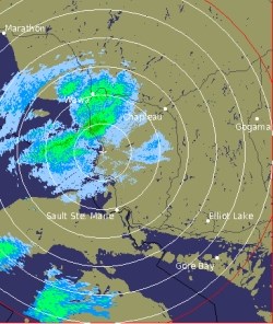
The radar image shown was taken at 9:50 a.m.
We've also included a winter weather advisory issued by the U.S. National Weather Service.
************************* Environment Canada
Significant snowfall today and tonight.
A Colorado winter storm is tracking northeastward and will reach Georgian Bay by evening.
Snow ahead of this system has already spread across regions located east of Lake Superior to the Nickel Belt region last night.
The snow will continue today and through the evening before tapering off to isolated flurries overnight.
Snowfall is expected to be at times heavy this afternoon as the Colorado low gets closer to the warned areas.
This will affect regions from Sault Ste. Marie east to the Nickel Belt with total snowfall amounts of 15 centimetres likely by late afternoon or evening.
The snow will be at times mixed with periods of light freezing rain over regions north of the North Channel today.
************************* U.S. National Weather Service
MORE SNOW ON THE WAY TODAY.
LOW PRESSURE ORGANIZING OVER THE MID MISSISSIPPI VALLEY REGION THIS MORNING WILL RACE NORTHEAST ACROSS CENTRAL MICHIGAN THIS AFTERNOON.
SNOW - LOCALLY HEAVY WILL RAPIDLY OVERSPREAD THE AREA LATER THIS MORNING.
THE SNOW WILL CONTINUE THROUGH THIS EVENING BEFORE TAPERING OFF.
TRAVEL TODAY IS EXPECTED TO BE SIGNIFICANTLY IMPACTED SO PLAN ACCORDINGLY.
CHIPPEWA-MACKINAC, INCLUDING THE CITIES OF SAULT STE. MARIE AND ST. IGNACE.
WINTER WEATHER ADVISORY IN EFFECT UNTIL 10 PM EST THIS EVENING.
THE NATIONAL WEATHER SERVICE IN GAYLORD HAS ISSUED A WINTER WEATHER ADVISORY FOR SNOW, WHICH IS IN EFFECT UNTIL 10 PM EST THIS EVENING.
SNOW WILL DEVELOP FROM SOUTH TO NORTH LATER THIS MORNING.
STEADY SNOW IS EXPECTED TO CONTINUE THROUGH THIS AFTERNOON, WITH 3 TO 5 INCHES OF ACCUMULATION EXPECTED BY THIS EVENING.
THE HEAVIEST SNOW AMOUNTS WILL FALL ALONG AND EAST OF I-75.
ADDITIONAL ACCUMULATIONS OF 1 TO 2 INCHES ARE EXPECTED THIS EVENING, ESPECIALLY IN FAVOURED LAKE EFFECT AREAS.
A WINTER WEATHER ADVISORY FOR SNOW MEANS THAT PERIODS OF SNOW WILL CAUSE TRAVEL DIFFICULTIES.
BE PREPARED FOR SNOW COVERED ROADS AND LIMITED VISIBILITIES, AND USE CAUTION WHILE DRIVING.
*************************