Environment Canada is maintaining the snow squall warning below for Agawa - Lake Superior Park - Wawa - Pukaskwa Park - White River - Dubreuilville.
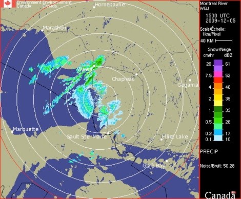
The Environment Canada radar image show was taken at approximately 11 a.m. today.
The Environment Canada warning is followed by a U.S. National Weather Service warning for a widespread area, including Chippewa County. ************************* Environment Canada
Snow squalls with whiteouts from heavy snow today but finally coming to an end tonight.
Heavy flurries and local snow squalls continue to affect locales to the northeast of Lake Superior from north of Montreal River to Wawa and into Pukaskwa.
They will extend as far inland as White River at times and will continue today before finally being pushed southwards tonight as a trough of low pressure moves through.
Latest weather radar shows the strongest snow squall extending from Lake Superior northeast over the Wawa area then inland across highways 17 and 519 to near Dubreuilville.
Local snowfall accumulations of 15 centimetres are expected in the heavier snow squalls.
In addition low to at times nil visibilities in bursts of heavy snow are expected.
Motorists should be prepared for dangerous winter driving conditions and allow extra time to reach their destination.
Whiteout conditions in heavy snow can often develop suddenly even when conditions just prior to the snow squall included good visibility with little or no snow.
************************* U.S. National Weather Service
FIRST SIGNIFICANT LAKE EFFECT SNOWS OF THE SEASON TO CONTINUE.
SIGNIFICANT LAKE EFFECT SNOWFALL WILL CONTINUE TO IMPACT PORTIONS OF NORTHWEST LOWER AND EASTERN UPPER MICHIGAN THROUGH THIS AFTERNOON AND INTO THIS EVENING.
A PERSISTENT SOUTHWEST WIND FLOW OVER LAKE MICHIGAN IS EXPECTED TO FOCUS A HEAVY SNOW BAND INTO FAR NORTHERN LOWER MICHIGAN AND ALONG THE SOUTHERN COASTLINE OF EASTERN UPPER MICHIGAN.
HEAVY LOCALIZED ACCUMULATION ARE EXPECTED.
CHIPPEWA-MACKINAC-EMMET-CHEBOYGAN-CHARLEVOIX INCLUDING THE CITIES OF SAULT STE. MARIE, ST. IGNACE, PETOSKEY, CHEBOYGAN, CHARLEVOIX.
A LAKE EFFECT SNOW WARNING REMAINS IN EFFECT UNTIL 6 PM EST THIS EVENING.
PERSISTENT SOUTHWEST WINDS OVER NORTHERN LAKE MICHIGAN WILL CONTINUE TODAY INTO THIS EVENING PROVIDING BANDS OF HEAVY LAKE EFFECT SNOW.
AREAS MOST LIKELY TO BE TARGETED BY THE HEAVIEST SNOW INCLUDE SOUTHEAST CHIPPEWA AND FAR EASTERN MACKINAC COUNTY AS WELL AS EMMET, WESTERN CHARLEVOIX AND WESTERN CHEBOYGAN COUNTIES.
ADDITIONAL SNOW TOTALS 4 TO 7 INCHES ARE LIKELY BY THIS EVENING.
THE HIGHEST AMOUNTS ARE EXPECTED IN EMMET COUNTY.
A LAKE EFFECT SNOW WARNING MEANS LOCALIZED HEAVY LAKE EFFECT SNOW IS FORECAST THAT WILL MAKE TRAVEL VERY HAZARDOUS.
*************************