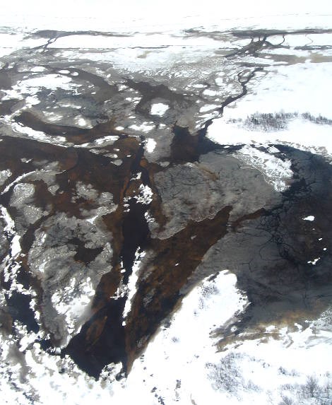
Flying over the mouth of the Goulais River on Goulais Bay this afternoon, it was evident that the ice is breaking up and plenty of water is flowing out of the river.
Kirk Dillabough is a Ministry of Natural Resources section chief and one of the authorities responsible for river monitoring.
Dillabough, a natural resource managment technologist, said that ice at the mouth of the river seems to be breaking up more than it was in the past few days.
He and helicopter pilot Pat Dickey discussed the situation during a recognisance flight with SooToday.com between 1 and 2 p.m. today.
"There is a lot more open water down there than before," said Dillabough. "But if the ice backs things up, the water will have nowhere to go."
He gestured to a number of houses and outbuildings close to the river's edge and not far from the mouth of the river.
"The water went right over this area and across the road in 1988," Dillabough said. "And that field over there was completely submerged."
The visual inspection also included some low flying to check on banks where old washouts were evident.
Dillabough said he was concerned about bank stability in these and a few other areas on the very crooked river.
There were no areas we could see where the river had broken out of its banks today.
But much of the area was wet as yesterday's snow melted.
Dillabough said the ministry will continue with aerial inspections of the river today and coordinate those with ground visual inspections assisted by Goulais River Volunteer Fire Department members.
During a short rest stop on the ground, we happened across three volunteer firefighters on flood watch patrol and they reported the river didn't appear to be in immediate danger of breaching its banks in any areas they could see from the road.
Our inspection took about an hour, with a 15 minute break. Dickey took off from the Bushplane Heritage Centre around 1 p.m., flew east and north across the Sault, then roughly up Highway 17 for a bit before reaching Goulais Bay..
There, he banked sharply and began to follow the river back toward the highway.
After the break, Dickey continued along the river to Searchmont then flew back to the Bushplane Heritage Centre.