The following winter storm warning has been issued tonight for Wawa - Pukaskwa Park - White River - Dubreuilville - Kapuskasing - Hearst - Smooth Rock Falls - Fraserdale - Pledger Lake.
Similar warnings are in effect for a swath of Northern Ontario extending from Kenora to the Timmins-Cochrane region.
Earlier storm watches issued for Searchmont - Montreal River Harbour - Batchawana Bay - Agawa - Lake Superior Park - Chapleau - Missinaibi Lake - Gogama - Foleyet are no longer in effect.
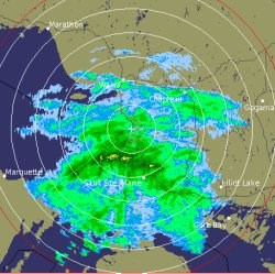
The radar image shown was taken at 8:50 p.m. Saturday.
************************* Major winter storm tonight to Monday morning.
This is a warning that dangerous winter weather conditions are imminent or occurring in these regions.
Monitor weather conditions. Listen for updated statements.
A major winter storm brewing over Wyoming will move towards Lake Superior by Sunday.
This will affect Northern Ontario with snow beginning later this evening near Lake of The Woods.
The snow will spread east through the warned regions overnight with heavy snow continuing to fall through the day on Sunday.
Most regions will see around five to 10 centimetres of snow fall by Sunday morning with an additional 15 to 25 centimetres of snow by Monday morning.
Regions along the western and northern shores of Lake Superior will see locally higher amounts since they will be closer to the centre of the storm.
This storm will be accompanied by strong winds which will whip around the freshly fallen snow and cause areas of blowing snow reducing visibility at times.
Tonight, cold northeast or north winds with gusts to 50 kilometres and hour will produce cold wind chill values near minus 35 to 40 particularly over northwestern Ontario where a wind chill warning is in effect for Red Lake and Kenora.
The frigid wind chill conditions will return Sunday night and spread eastward to regions north of Lake Superior as the storm moves towards northeastern Ontario.
Kapuskasing and Timmins will receive slightly lesser snow amounts than their neighbours to the west.
Furthermore, the wind chill values will not be as cold since they will escape the brunt of the frigid Arctic air which will sweep in behind the storm.
This is the reason they are under a snowfall warning instead of a winter storm warning.
This storm will make travel difficult and dangerous due to the snowfall amount - reduced visibilities in blowing snow and cold wind chill values for over 24 hours in some locations. *************************