SooToday.com has received the following special weather statement this morning from Environment Canada.
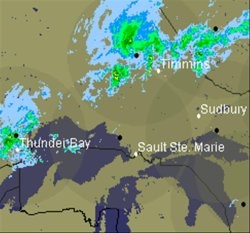
The Environment Canada composite radar image shown was taken at 10:50 a.m.
************************* Special weather statement issued by Environment Canada Ontario region.
Special weather statement issued for City of Thunder Bay - Kenora - Nestor Falls - Dryden - Ignace - Fort Frances - Rainy Lake - Atikokan - Upsala - Quetico - Superior West - Red Lake - Ear Falls - Sioux Lookout - Savant Lake - Lake Nipigon - Wabakimi - Geraldton - Manitouwadge - Hornepayne - Nipigon - Marathon - Superior North - Wawa - White River - Pukaskwa - Sault Ste. Marie - Superior East - Kapuskasing - Hearst - Timmins - Cochrane - Greater Sudbury and Vicinity - Chapleau - Gogama - Kirkland Lake - New Liskeard - Temagami - Elliot Lake - Ranger Lake - Manitoulin - Northshore - Killarney - North Bay - West Nipissing.
Snow today, frost tonight
The passage of an Arctic cold front will usher in much cooler air across the district today.
A swath from Red Lake to Timmins will likely see rain changing to snow this morning before the precipitation tapers off from northwest to southeast throughout the day.
Snowfall amounts are expected to be light, however, a few centimetres are possible.
Partial clearing combined with light winds tonight will produce favourable conditions for frost.
Temperatures are expected to drop to near or below the freezing mark in all of the above regions.
A frost warning will likely be issued later today.
*************************