Environment Canada has issued the following snow squall warning for Sault Ste. Marie - St. Joseph Island - Searchmont - Montreal River Harbour - Batchawana Bay.
We have also included the latest lake effect snow warning issued from the Michigan Soo by the U.S. National Weather Service.
****************************** Snow squalls continuing this afternoon.
Flurries with local snow squalls will continue through this afternoon.
There have been reports of as much as 25 centimetres of snow within the warned regions, with additional local accumulations of 5 to 10 centimetres possible this afternoon.
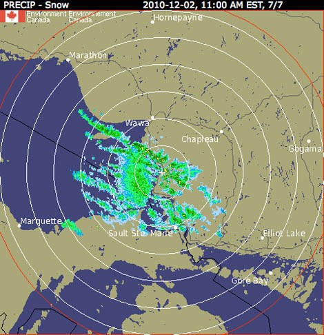
The main snow squall band over Lake Superior which was affecting the city of Sault Ste Marie early this morning has become a bit disorganized.
However, flurries at times heavy with embedded snowsqualls will continue into the afternoon.
Driving conditions may deteriorate quickly in flurries and snow squalls.
Motorists should be prepared for sudden whiteout conditions from bursts of heavy snow, and adjust travel plans accordingly.
Environment Canada will continue to monitor this situation and issue additional snow squall warnings if necessary.
****************************** WINTER WEATHER MESSAGE NATIONAL WEATHER SERVICE GAYLORD MI
SIGNIFICANT LAKE EFFECT SNOW CONTINUES.
AN EXTENDED PERIOD OF LAKE EFFECT SNOWFALL WILL CONTINUE ACROSS NORTHERN MICHIGAN TODAY THROUGH FRIDAY MORNING.
WEST-NORTHWEST WINDS ACROSS LAKES SUPERIOR AND MICHIGAN WILL BRING ACCUMULATING SNOWS TO NORTHERN CHIPPEWA COUNTY AND PARTS OF NORTHWEST LOWER MICHIGAN NORTH OF M-72.
CHIPPEWA - INCLUDING THE CITY OF SAULT STE. MARIE
LAKE EFFECT SNOW WARNING REMAINS IN EFFECT UNTIL 5 AM EST FRIDAY.
A LAKE EFFECT SNOW WARNING REMAINS IN EFFECT UNTIL 5 AM EST FRIDAY.
IMPACTS
HAZARDOUS TRAVEL CONDITIONS WILL CONTINUE THROUGH LATE TONIGHT, WITH THE MOST SIGNIFICANT SNOWFALL ALONG AND NORTH OF M-28. ROADS, ESPECIALLY SECONDARY AND UNTREATED SURFACES, WILL REMAIN SNOW COVERED WITH SUBSTANTIALLY REDUCED VISIBILITIES IN BANDS OF HEAVY LAKE EFFECT SNOW.
HAZARDOUS WEATHER
LAKE EFFECT SNOW, HEAVY AT TIMES, WILL CONTINUE THROUGH THE DAY. ACCUMULATIONS OF UP TO 10 INCHES ARE EXPECTED THROUGH DAYBREAK FRIDAY WHERE SNOW SHOWERS PERSIST.
PRECAUTIONARY/ PREPAREDNESS ACTIONS
A LAKE EFFECT SNOW WARNING MEANS LOCALIZED HEAVY LAKE EFFECT SNOW IS FORECAST THAT WILL MAKE TRAVEL VERY HAZARDOUS.
*************************