Environment Canada has issued the following blowing snow warning for Sault Ste. Marie - St. Joseph Island - Searchmont - Batchawana Bay - Montreal River Harbour - Ranger Lake - Thessalon - Blind River - Elliot Lake - Espanola - the North Shore - Killarney - Manitoulin - Chapleau - Gogama - Foleyet - Missinaibi Lake.
A similar warning extends through Greater Sudbury and vicinity - North Bay and West Nipissing - Hearst - Kapuskasing - Smooth Rock Falls - Kirkland Lake - Englehart - New Liskeard - Temagami - Timmins - Chochrane - Iroquois Falls.
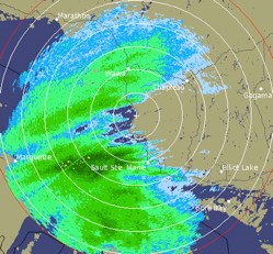
The Environment Canada radar image shown was taken at 8:41 p.m. today.
The Environment Canada warning is followed by a U.S. National Weather Service winter weather warning for Chippewa and Mackinac Counties.
************************* Environment Canada
Extensive blowing snow and very cold temperatures Friday giving near-blizzard conditions.
An intense low pressure system from Kansas will pass just south of the regions early Friday bringing a major storm with and blowing snow to the regions.
Snow will develop over all regions this evening.
Snowfall amounts of to 20 to 30 centimetres are expected over southeastern portions of Northern Ontario including the Nickel Belt.
Further northwest snowfall amounts will taper off to about 10 centimetres.
Strong northerly winds gusting to 60 to 70 km/h will develop early Friday giving extensive blowing snow.
Bitterly cold temperatures combined with the snow and the wind will produce near blizzard conditions at times.
Conditions will begin to improve near Lake Superior near noon Friday with the improvement spreading eastward to reach areas near the Québec border in the evening.
************************* U.S. National Weather Service
QUICK HITTING BUT SIGNIFICANT WINTER STORM TONIGHT.
LOW PRESSURE SOUTHWEST OF CHICAGO AT MID EVENING WILL CROSS SOUTHERN LOWER MICHIGAN OVERNIGHT SPREADING A WIDE SWATH OF WINTRY PRECIPITATION ACROSS NORTHERN MICHIGAN.
PRECIPITATION TYPE WILL VARY ACROSS THE REGION, WITH PRIMARILY SNOW EXPECTED ACROSS EASTERN UPPER AND PORTIONS OF NORTHERN LOWER MICHIGAN NORTH OF M-72.
ALONG AND SOUTH OF THE M-55 CORRIDOR WILL BE MOSTLY RAIN, WHILE IN BETWEEN WILL BE A STRIP OF MIXED SNOW, SLEET AND RAIN OR FREEZING RAIN DEPENDING ON SURFACE TEMPERATURES WHICH WILL LIKELY BE HOVERING RIGHT AROUND THE FREEZING MARK.
ALTHOUGH THE HEAVIEST PRECIPITATION WILL OCCUR OVER A 6 TO 9 HOUR TIME PERIOD, PRECIPITATION IS EXPECTED TO BE INTENSE WITH SOME EMBEDDED THUNDERSTORMS.
GIVEN THE WIDE VARIATION IN TEMPERATURE OVER A SHORT DISTANCE ASSOCIATED WITH THIS STORM, ANY SMALL DEVIATION IN EXPECTED TRACK COULD RESULT IN AREAS EXPECTED TO RECEIVE HEAVY SNOW PICKING UP MORE SLEET, FREEZING RAIN OR HEAVY RAINFALL INSTEAD.
THIS IS ESPECIALLY TRUE FOR AREAS ALONG THE M-72 CORRIDOR WHERE SEVERAL PRECIPITATION TYPES ARE POSSIBLE.
BE SURE TO MONITOR CURRENT CONDITIONS BEFORE VENTURING OUT TONIGHT.
CHIPPEWA-MACKINAC-INCLUDING THE CITIES OF SAULT STE. MARIE, ST. IGNACE.
A WINTER STORM WARNING REMAINS IN EFFECT UNTIL 7 AM EST FRIDAY.
SNOW WILL OVERSPREAD THE AREA THIS EVENING AND BECOME HEAVY AT TIMES BEFORE TAPERING OFF BY 4 AM.
A TOTAL ACCUMULATION OF 5 TO 10 INCHES OF HEAVY WET SNOW IS EXPECTED DURING THIS TIME, WITH SNOW BRIEFLY FALLING AT THE RATE OF 1 TO 2 INCHES PER HOUR DURING THE LATE EVENING.
HEAVIEST SNOWFALL IS EXPECTED ACROSS EASTERN PORTIONS OF CHIPPEWA AND MACKINAC COUNTIES.
A WINTER STORM WARNING FOR HEAVY SNOW MEANS SEVERE WINTER WEATHER CONDITIONS ARE EXPECTED OR OCCURRING.
SIGNIFICANT AMOUNTS OF SNOW WILL MAKE TRAVEL DANGEROUS.
IF YOU MUST TRAVEL, USE EXTREME CAUTION.
*************************