The U.S. National Weather Service has issued the following winter storm warning for much of northern Michigan, including Chippewa County and the Michigan Soo.
Also issue earlier this evening for much of northern Michigan is a dense fog advisory.
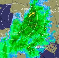
Additionally, Environment Canada issued the following rainfall warning earlier today for Manitoulin Island - Espanola - Killarney.
Similar warnings are in effect for the Greater Sudbury and vicinity, and North Bay - West Nipissing regions.
The Environment Canada radar image shown was taken at 7:10 p.m. this evening.
************************* U.S. National Weather Service - winter storm warning
BLAST OF COLD AIR AND GUSTY WINDS STARTING LATE TONIGHT
AFTER A WARM, FOGGY AND RAINY PERIOD, COLDER AIR WILL SURGE BACK INTO THE REGION SUNDAY MORNING BEHIND A STRONG COLD FRONT.
THIS AIR WILL BE BROUGHT IN BY VERY GUSTY WEST WINDS THAT WILL BLAST THROUGH THE NORTH WOODS.
IN ADDITION, SNOW, BRIEFLY HEAVY IN SOME LOCATIONS, WILL DEVELOP EARLY SUNDAY MORNING.
THE COMBINATION OF SNOW AND STRONG GUSTY WINDS MAY RESULT IN NEAR BLIZZARD CONDITIONS FOR SOME AREAS.
CHIPPEWA - MACKINAC - EMMET - CHEBOYGAN - CHARLEVOIX - LEELANAU - ANTRIM - OTSEGO - BENZIE - GRAND TRAVERSE - KALKASKA - CRAWFORD - MANISTEE - WEXFORD - INCLUDING THE CITIES OF SAULT STE. MARIE, ST. IGNACE, PETOSKEY, CHEBOYGAN, CHARLEVOIX, NORTHPORT, MANCELONA, GAYLORD, FRANKFORT, TRAVERSE CITY, KALKASKA, GRAYLING, MANISTEE, CADILLAC
THE NATIONAL WEATHER SERVICE IN GAYLORD HAS ISSUED A WINTER STORM WARNING FOR SNOW AND BLOWING SNOW, WHICH IS IN EFFECT FROM 5 AM TO 5 PM EST SUNDAY.
THIS REPLACES THE PREVIOUSLY ISSUED WINTER STORM WATCH.
RAIN WILL CHANGE RAPIDLY OVER TO SNOW EARLY SUNDAY MORNING, WHILE WINDS WILL BECOME VERY GUSTY, REACHING 30 TO POSSIBLY 40 MPH.
THE GREATEST SNOW ACCUMULATIONS ON SUNDAY ARE MOST LIKELY TO OCCUR ACROSS EASTERN UPPER MICHIGAN WHERE 2 TO 5 INCHES ARE EXPECTED.
ACROSS NORTHWEST LOWER MICHIGAN, ONLY A FEW INCHES OF SNOW WILL ACCUMULATE BY THE END OF THE DAY.
BUT REGARDLESS OF ACCUMULATIONS, STRONG WINDS WILL PRODUCE BLOWING AND DRIFTING SNOW AND SIGNIFICANTLY REDUCED VISIBILITIES CREATING A PERIOD OF NEAR BLIZZARD CONDITIONS SUNDAY MORNING.
THE SNOW WILL QUICKLY TAPER OFF SUNDAY AFTERNOON, BUT WINDS WILL REMAIN GUSTY.
A WINTER STORM WARNING FOR SNOW AND BLOWING SNOW MEANS SEVERE WINTER WEATHER CONDITIONS ARE EXPECTED.
SNOW AND BLOWING SNOW WILL MAKE TRAVEL DANGEROUS.
IF YOU MUST TRAVEL, USE EXTREME CAUTION.
Dense fog advisory
CHIPPEWA - MACKINAC - EMMET - CHEBOYGAN - PRESQUE ISLE - CHARLEVOIX - LEELANAU - ANTRIM - OTSEGO - MONTMORENCY - BENZIE - GRAND TRAVERSE - KALKASKA - CRAWFORD - OSCODA - MANISTEE - WEXFORD - MISSAUKEE - ROSCOMMON - INCLUDING THE CITIES OF SAULT STE. MARIE, ST. IGNACE, PETOSKEY, CHEBOYGAN, ROGERS CITY, CHARLEVOIX, NORTHPORT, MANCELONA, GAYLORD, ATLANTA, FRANKFORT, TRAVERSE CITY, KALKASKA, GRAYLING, MIO, MANISTEE, CADILLAC, LAKE CITY, HOUGHTON LAKE
A DENSE FOG ADVISORY REMAINS IN EFFECT UNTIL 1 AM EST SUNDAY.
WARM AIR OVER THE COLD SNOW PACK WILL LEAD TO WIDESPREAD DENSE FOG THROUGH A GOOD PORTION OF TONIGHT.
ALTHOUGH SOME THINNING OF THE FOG IS POSSIBLE AT TIMES, VISIBILITIES LESS THAN ONE QUARTER MILE WILL BE COMMON LEADING TO HAZARDOUS TRAVEL CONDITIONS.
IF DRIVING, SLOW DOWN, USE YOUR HEADLIGHTS AND LEAVE PLENTY OF DISTANCE BETWEEN YOU AND THE VEHICLE IN FRONT OF YOU.
************************* Environment Canada
Significant rain ending Sunday morning.
A low pressure system over Northern Ontario will draw significant rain and moisture into portions of the Nickel Belt region.
Rain, heavy at times, will move into this area by early afternoon.
This will continue into the evening and overnight hours then change to snow Sunday morning before ending.
Current indications suggest that the area from Manitoulin Island northeastward through Killarney, Sudbury, and North Bay, could receive between about 25 and 50 millimetres of rainfall in total by Sunday morning.
Additionally temperatures will continue to rise today, climbing to the high single digits.
These relatively high temperatures will accelerate melting of the existing snow pack and compound drainage and runoff concerns.
The patchy freezing rain which had been occurring over a large portion of Northern Ontario has tapered to patchy drizzle or freezing drizzle and the warnings have been ended.
Environment Canada continues to closely monitor this situation.
*************************