Environment Canada has updated its snowsquall warning for Searchmont - Montreal River Harbour - Batchawana Bay - Agawa - Lake Superior Park.
A similar earlier warning has ended for Sault Ste. Marie and St. Joseph Island, as has an earlier similar wind warning for Blind River - Thessalon - Manitoulin Island - Espanola - Killarney.
The U.S. National Weather Service has issued a similar winter advisory for much of Northern Michigan, including Chippewa County and the Michigan Soo.
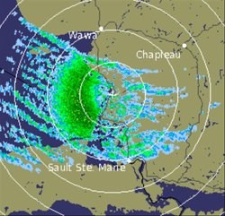
The Environment Canada radar image shown was taken at 3:50 p.m.
************************* Environment Canada
Snowsqualls tonight and Tuesday.
This is a warning that snowsqualls are imminent or occurring in these regions.
Monitor weather conditions.
The major winter storm is centred over northern Québec and the snow is gradually tapering off across Northeastern Ontario.
Some residual lighter snow and some blowing and drifting snow is still evident but only minor additional snowfall amounts are on tap.
Many regions saw between 15 and 25 centimetres from the storm.
In the Northwest, cold westerly winds up to 30 kilometres per hour is producing cold wind chill values near or just below minus 40.
These harsh wind chill values are expected to continue tonight into Tuesday morning before easing as winds gradually abate.
To the east of Lake Superior, snowsqualls are active once again as cold Arctic air streams across the region.
The squalls will affect the Sault Ste. Marie areas for awhile this evening before shifting back north again.
The warning is ended for Sault Ste. Marie since they will not receive significant amounts of snow.
However, brief bursts of heavy flurries may be expected this evening giving a few centimetres and local reduced visibility in blowing snow.
Local snowfall amounts of 15 centimetres in 12 hours are possible under stationary squalls from Batchawana Bay and northwards.
Strong winds with gusts to 60 kilometres per hour will continue to reduce visibilities to near zero at times in blowing snow this evening but the winds should ease a little overnight.
************************* U.S. National Weather Service
GUSTY WINDS AND LAKE EFFECT SNOWS CONTINUE
LAKE EFFECT SNOW WILL CONTINUE ACROSS NORTHWEST LOWER MICHIGAN AND NORTHERN SECTIONS OF EASTERN UPPER MICHIGAN THROUGH THIS EVENING.
FALLING SNOW COMBINED WITH VERY GUSTY WESTERLY WINDS WILL RESULT IN BLOWING SNOW WITH FREQUENTLY REDUCED VISIBILITIES.
CHIPPEWA - EMMET - CHEBOYGAN - PRESQUE ISLE - CHARLEVOIX - LEELANAU - ANTRIM - OTSEGO - MONTMORENCY - ALPENA - BENZIE - GRAND TRAVERSE - KALKASKA - CRAWFORD - MANISTEE - WEXFORD - MISSAUKEE - INCLUDING THE CITIES OF SAULT STE. MARIE, PETOSKEY, CHEBOYGAN, ROGERS CITY, CHARLEVOIX, NORTHPORT, MANCELONA, GAYLORD, ATLANTA, ALPENA, FRANKFORT, TRAVERSE CITY, KALKASKA, GRAYLING, MANISTEE, CADILLAC, LAKE CITY.
THE WINTER WEATHER ADVISORY IS NOW IN EFFECT UNTIL 11 PM EST THIS EVENING.
LAKE EFFECT SNOW AND BLOWING SNOW IS EXPECTED TO CONTINUE THROUGH THIS EVENING.
ALTHOUGH SNOWFALL WILL ONLY BE IN THE 1 TO 3 INCH RANGE, WITH LOCALLY HIGHER AMOUNTS NEAR WHITEFISH POINT, WIND GUSTS BETWEEN 25 AND 35 MPH WILL RESULT IN SIGNIFICANT BLOWING SNOW AND REDUCED VISIBILITIES.
BOTH WIND AND SNOW SHOULD SUBSIDE AFTER MIDNIGHT.
A WINTER WEATHER ADVISORY FOR SNOW AND BLOWING SNOW MEANS THAT VISIBILITIES WILL BE LIMITED DUE TO A COMBINATION OF FALLING AND BLOWING SNOW.
USE CAUTION WHEN TRAVELING, ESPECIALLY IN OPEN AREAS.
*************************