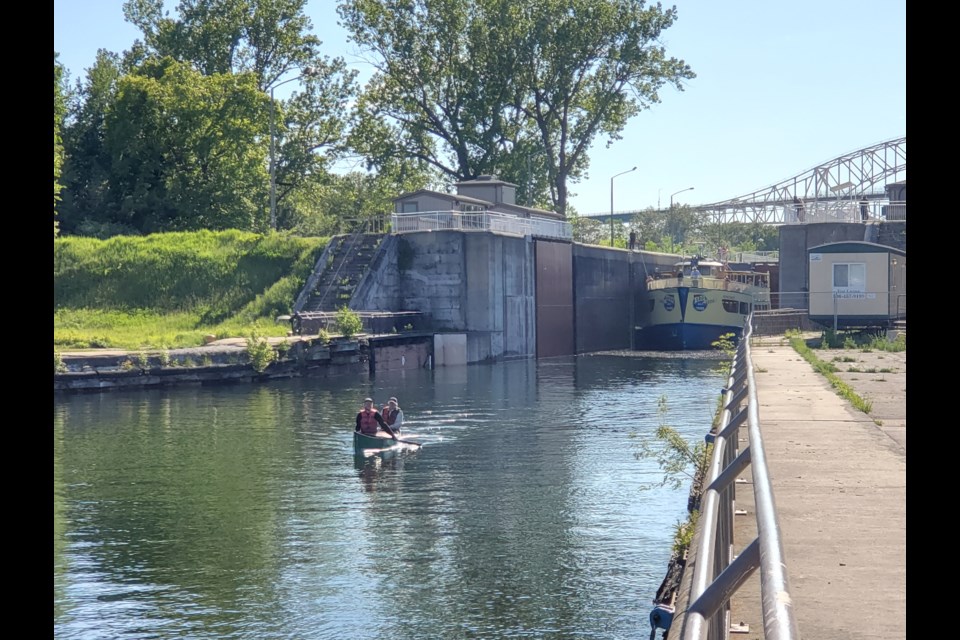
As David and Daniel Gardner paddled into the historic lock of the Sault Ste. Marie Canal, reaching the end of their 23-day, 650-plus kilometre journey, they were greeted by a stranger who called out, “Hey there . . . did you drop something in the lake?”
Four days prior and 200 kilometres to the north along the coast of Lake Superior at Agawa Bay, a not-quite waterproof zipper bag containing a set of maps washed up on the beach. Out walking his dog on the beach that evening, camper Jake Cormier came across the bag, floating just off shore.
“At first I thought, oh, some boater dropped their maps into the lake,” said Cormier, who is a finance and general management type for SooToday's parent company, Village Media. “I suppose they’ll have a little harder time navigating the shoreline now. But then I got thinking . . . was this all that went overboard?”
Cormier took the envelope back to his campsite to dry out the maps, which had taken on a little water. At that point, he realized these were not simply maps.
On the back of the maps, which ran the shoreline from Thunder Bay to French River, was a daily log of some canoers who set out from Thunder Bay on May 25.
“It was this incredible journey being made by a 65-year-old man and his son. The man turned 65 a few days into the trip. I realized, never mind the maps, these guys must have been quite upset at the loss of this detailed record of their amazing trip.”
At this point it was Thursday, June 13, and the last log entry was on June 12 from Gargantua.
That final log entry was ominously titled “the day from hell.”
Anyone at all familiar with Superior will know that it is completely unpredictable and quite a dangerous body of water for boats of any size.
It was then that Cormier put the call out on social media for everyone along the shore to keep an eye out for a canoe making its way down from Thunder Bay. Staff across the vast Lake Superior Provincial Park were alerted. The Ontario Provincial Police were also involved, attempting to track down and contact some of the names mentioned in the journal entries to ensure these paddlers were safe.
At this point there was no indication that anyone was in danger, short of being a little more navigationally challenged. Nothing else washed up on shore. That day was rather windy, so Cormier’s gut feeling was that a gust of wind simply caught the maps and threw them in the lake.
It wasn’t until Saturday, two days later, that the first sightings of the canoe came in.
On June 12, the Gardners were rounding Agawa Rock and the pictographs, into the bay.
“As we came out of the shelter of the mountain behind us, the wind very rapidly came up behind us and carried the map off the canoe,” said Dan. “It was sitting on the cover, and it carried it right off. At that point, the wind had picked up to such an extent that we did not find it safe to turn around. We were moving along at such a rapid pace from the tailwind. It was whitecapping. Even if we had tried to slow the canoe with our paddles, the map was already way behind us. With that kind of wind, turning around a canoe is like a life and death proposition; you don’t even think about doing it.”
The men described being disappointed in the loss of their maps, but profoundly sad at the loss of the journal of their trip up to that point.
“It was an emotional moment and subsequent end of the day.”
“I was sort of processing it and was thinking ‘How can we rebuild from our memory some of the day to day things?'" said Dan’s father, Dave. “It was so sad.”
“We both independently had asked ourselves, well, what happens if somebody finds the map, once we knew we weren’t going to find it. Is there any way they’ll be able to track us down? What are the odds, you know? We both concluded the odds were practically zero.”
As far as navigation went, fortunately they had a backup albeit less detailed map on hand.
“We had another few hours to go that day,” said Dan. “We had hoped to get to the end of Agawa Bay and into MacGregor Cove. As soon as the maps flew away, we decided to let ourselves be drifted directly downwind until we hit the beach. We found a place to set up camp right by the mouth of the Agawa River. We thought if we were to have a chance of finding the maps, this would be our best chance. So we scouted the shoreline that night and the next morning as well, with no luck until they showed up today in Jake’s hands at the locks.”
Dave, a retired businessman, and Dan, a civil engineer, hail from the Greater Toronto Area, but they are no stranger to the canoe nor to long paddling trips like this.
They’ve paddled the Missinabie River from near Hearst all the way to the James Bay, a trip of some 300km through one of the most remote parts of the continent. They’ve paddled along the Quebec shore of the Gulf of St. Lawrence, stopping at fishing villages where no roads go.
“We were both aware of the historic aspect of this canoe trip,” said Dave. “Of course, for millennia our first nations paddled it, followed by the fur traders. To be able to paddle a route that is mostly still as it always was… you’re seeing the same rocks... it’s 95 per cent the same. Vast, vast stretches of it, once you’re away from Thunder Bay and from the Sault. That is something very, very special, because it’s just timeless.”
“That for me is one of the things I love about canoeing, is that it’s like a time machine. We’re in a kevlar canoe, so it’s modern materials, but it’s the same. It’s the same stroke, the same view, the same wind and rain and fog. In the world we live in, which is so sophisticated and so detached from nature and from real things . . . it’s a time machine.”
This journey indeed carried the Gardners past many historic places on the coast, and countless natural wonders that few people have seen even to this day, in this still-wild and difficult to access part of an otherwise bustling province.
Places like Sleeping Giant, Silver Islet, Nipigon Bay and St. Ignace Island, Schreiber, Marathon, Heron Bay, the Pukaskwa Coast, Otter Island and Old Dave’s Harbour, Old Woman Bay, Gargantua and Devil’s Warehouse stood out in particular.
Also, Goulais Bay.
“Goulais Bay was toasty warm at the end,” laughed Dan.
Compared to further north on the lake, where they awoke one morning to find a thin sheet of ice had formed over the bay, perhaps Goulais Bay could be called warm.
The trip didn’t really have a schedule, mostly owing to the unpredictability of the lake. They ended up paddling for about 12 hours and 50 kilometres a day.
“I think one of the characteristics of a trip like this is that you really can’t do a lot of planning,” said Dave. “You can’t plan where you’re going to camp, you can’t plan how far you’re going to go. You have general ideas, but you certainly don’t plan your next campsite.”
“You just see where you end up, which all depends on the wind and the sea conditions, and then you just try your best to find a place you can set up. Sometimes you’re lucky and you have a nice spot, and other times you’re perched on the side of a rock or something. It’s one of the very interesting elements of a trip on Lake Superior. The plan is really just to go with the flow.”
At one point, they had to stay put for two days waiting for the wind to die down. At another point, the big lake’s moodiness really let itself be known.
“My first scary moment was really on our third or fourth day,” said Dave. “We had just passed by Silver Islet, an old silver mine on an island east of Sleeping Giant. We were heading across the bay, and there was just a ripple.”
“It was like glass,” said Dan.
“So we committed ourselves to head out towards an island halfway across, Cranberry Island, probably a two- or three-kilometre crossing. Sure enough, the wind starts to pick up, and pick up, and pick up. Soon, within 20 minutes, it’s just roaring and whitecapping.”
“Fortunately, we had lined it up so the island was straight downwind. But we could not have gone anywhere else. So that was our wake-up call. We just whipped around the back of the island and just managed to escape that.”
Is it possible to gain confidence in a paddling journey like this on Lake Superior?
“Speaking for myself, gradually confidence grows, but on the other hand, that’s scary because it’s easy to be overconfident,” said Dave. “We always have to have an ‘out’. Whenever we were doing a crossing, we had to say ‘okay if the wind comes up, what’s our out? Where can we go downstream, downwind to get out of this?’”
“You can’t go hiking without risk. You can’t paddle Lake Superior without risk. You have to take some calculated risks. That’s the nature of the game.”
“It connects us with the past, in that sense,” said Dan. “The world is not a really safe place. There’s no ambulance out there on the lake.”
“So we took an approach that we wouldn’t cross large open crossings unless the conditions were optimal. Nonetheless, when we were near the shore, we did allow ourselves times to ride the rough seas. So we did find ourselves more than once, along the shore, in big waves, and it’s both exciting and terrifying at the same time.”
The men made the trip in a 16-foot kevlar canoe with a spray deck custom-made by Dan.
“It’s not your optimal canoe for this kind of trip.”
On Saturday, after the social media post had been shared over 500 times, reports started coming in of two men in a canoe passing by Old Mamainse Harbour. Then Coppermine Point.
The first confirmation that the men were safe, if that was them.
At this point, Cormier had pieced together enough clues from the journals to be able to call an acquaintance of theirs in Thunder Bay, and find out their names. Still, nobody knew how to contact the men.
On Sunday, a Facebook post from Goulais Bay:
"They yelled to us, 'Hey do you know who won the basketball championship?', so I stood up and shouted 'we won!' They told us they had been on a paddle from Thunder Bay and had no idea about the outcome of the series!"
On Monday, sightings came in from Gros Cap, and then Pointe Aux Pins.
Still, nobody had been able to communicate with the men. The Gardners didn’t know their journals had been found.
Cormier estimated they would be coming through the locks that afternoon by 5 or 6 p.m., and went down to meet them. At 5:45 p.m., two men in a green canoe came up the lock.
“Hey there,” said Jake. “Are you Dave and Dan? Did you drop something in the lake?” as he held up their bag of maps and journals.
“Yes! How did you find that? I can’t believe it!”
It turned out that where Cormier found the maps on the beach was only a few hundred metres from where the Gardners had set up camp, and on that same evening. If he hadn’t come across them, chances were that the Gardners would have found them the next morning.
“That’s why we couldn’t find them,” laughed Dan.
“But then I wouldn’t have this chance to make some new friends and learn all about their incredible trip down the coast,” said Cormier.
The Gardners didn’t actually have a plan for when they arrived in the Sault. They were hoping they could maybe store their canoe at a marina for a few days.
Cormier ended up still having the roof rack on his truck from the camping trip to Agawa. He met them at the marina, loaded their canoe onto the truck, and is storing it at his house until Dave comes back through from Thunder Bay later this week.
“Dan offered to have me join them in the future on the next leg of their trip from the Sault to French River,” said Cormier. “I fully intend to take them up on that!”