Just where is the best interpretative walking/hiking trail anyway?
You will have a list of contenders throughout Northern Ontario and their attributes can be assessed in many ways.
At this destination you will not want to go for a “quick hike.” We are now learning wetlands are important, but we still don’t know much about bogs, fens, swamps and ponds. We all have seen a pond or swamp of some description.
Marshes and swamps are one of the broadest categories of wetlands and, in general, harbour the greatest biological diversity and account for almost half of all wetlands throughout the world. We have different types of wetlands; we should come to know them like some of our familiar coniferous and deciduous trees.
The Winner
The wonders of Mashkinonje Provincial Park (pronounced mas-kin-onj) consist of a diverse system of wetlands supporting all the major wetland types - marshes, bogs, swamps, fens and ponds - interspersed with undulating granite ridges that cover more than 2,000 hectares between the West Arm and the West Bay of Lake Nipissing. The park counts among its many wetlands two provincially significant areas: the Loudon Basin Peatlands and Muskrat Creek.
Nature helped over time. The park’s features are the result of a post-glacial lake that covered the area combined with a series of parallel low elevation folded bedrock uplands. The low upland bedrock areas were wave washed with soils eroded and deposited in the depressions. Add the moisture and nutrient variability - wave action on Lake Nipissing - and the results are a variety of wetland habitats that make Mashkinonje a very interesting location to observe nature throughout the year.
But the real wonderment of this trail system is the interpretative signage. It is one of Ontario Parks' non-operating parks, so there are no fees and no operating dollars. The development and maintenance is directly linked to the local species of residents in the area, “the volunteer.”
Angela Martin is the past president the Friends of Mashkinonje for 14 years and of the provincial organization Ontario Nature (seven years), and a long-time resident and a former lodge owner in the West Nipissing area. In a past interview, she said, “I appreciate nature’s beauty, diversity and what it gives me and in return, I nurture the nature around me. These traits have led me to get involved with nature related organizations.”
The park was identified by the John Robarts government of 1963, and was expanded by the Mike Harris government's Living Legacy in program in 1997.
Originally it was named Haddo Provincial Park and appears that way on some older topographic maps. Thirty-eight percent of the park is wetland and there are “many little bridges” and boardwalks totalling more than one kilometre of construction. Martin explained a steering committee was formed in 1997 and then the Friends’ group was formed in 2000.
“A local group was organizing a steering committee to develop the Mashkinonje Provincial Park. I was asked to join the committee and ultimately set up a charity to develop the park, the Friends of Mashkinonje. I was president, and with the help of dedicated individuals, the Mashkinonje Provincial Park became a success with 35 kilometres of hiking and snowshoe trails, a barrier-free trail, boardwalks, a tower overlooking the peatlands, interpretive signage and more."
“A combined group of community and educational partners developed a system of hiking trails in the park to make the park features available to the public,” said Martin. “The interpretative signage is based on our local appreciation and knowledge of the area.”
Her philosophy reflects on what you will see at Mashkinonje.
“We are very lucky to live in this part of the world. Nature has so much to offer us but we have to look after it in return. Life is a two-way street," said Martin.
Importance
Martin notes that the two largest peat bogs in the world are located in western Siberia and in Northern Ontario.
Dr. Peter Beckett, Professor Emeritus, Laurentian University, is a biologist and one of the pioneers of Sudbury’s re-greening efforts. He has been to both and says if you can’t get to the Hudson's Bay or James Bay lowlands or Siberia, take a hike to the accessible Loudon peat bog.
“It is very representative," said Beckett.
Wetlands are often misunderstood because we usually think of them as a “swamp,” often in movies it is where the bodies are found.
At one time, everything was a "swamp," not a place to go for a holiday or spend some quality time. We are now learning wetlands are important but we still don’t know much about bogs, fens, swamps and ponds. And its ecological perceptions are changing. But wetlands, including swamps, bogs, fens and marshes, are of the highest ecological importance. It is an area where our ecological perceptions are changing.
“The Loudon peat bog is one-stop shopping,” Beckett said. “This trail system features all wetland types.”
“Ecologically speaking, wetlands are areas where water covers the soil or is present either at or near the surface of the soil all year or for varying periods of time during the year, including during the growing season. Water saturation largely determines how the soil develops and the types of plant and animal communities living in and on the soil. The prolonged presence of water creates conditions that favour the growth of specially adapted plants and promote the development of characteristic wetlands soils. Marshes and swamps are one of the broadest categories of wetlands and in general harbour the greatest biological diversity and account for almost half of all wetlands throughout the world. And one of the best is in our backyard.”
He said, “Northern Ontario is full of wetlands – swamps with tell-tale trees, marshes with magnificent moose, bogs and fens with countless cranberries and all the while capturing huge amounts of carbon and slowing climate change. The James Bay lowlands contain the second largest valuable peatland in the world. Mashkinonge – the park of wetlands - is a microcosm of the Province.”
Back Roads Choice
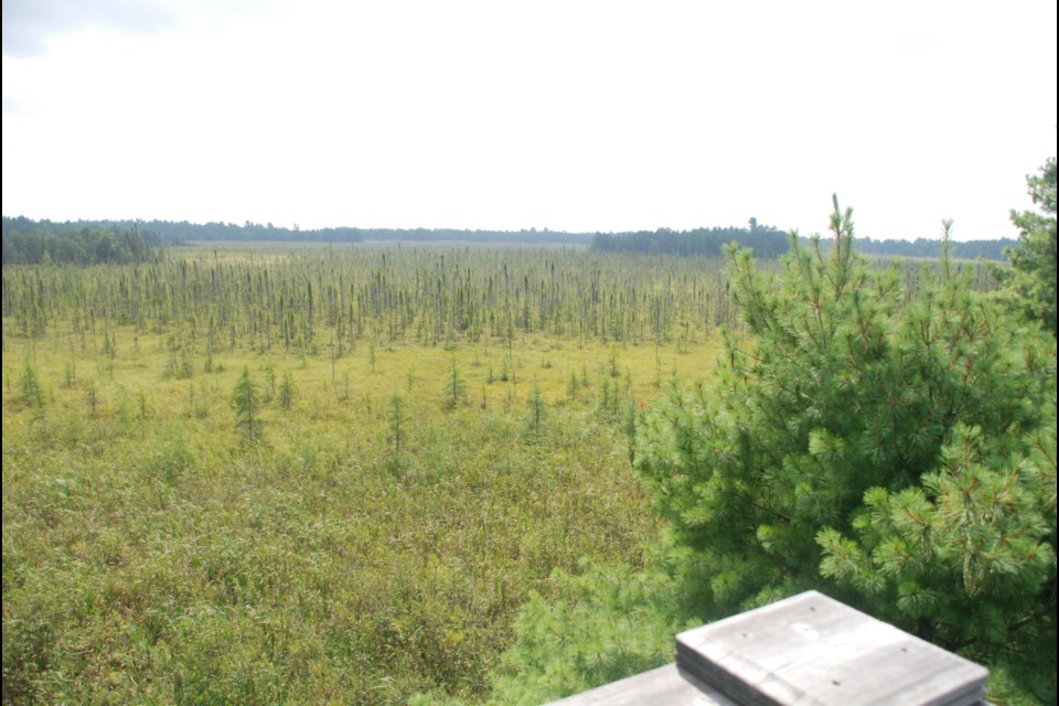
The Loudon Peatland Trail is Back Roads Bill’s choice not because of the 34 steps to-the-top lookout tower. There are more than four metres of peat below what you are looking out at. I have seen this before.
But more recently I have had knee surgery and knowing the healing powers of nature the Loudon Trail becomes the barrier-free choice when confined to a four-wheel walker or rollator.
The wide hard-pack trail and boardwalk leading to an expansive vista gives about two kilometres of walking. More than most accessibility trails.
There are plenty of trails to tackle on other days. On the west side of Highway 64 there are nine stacked loops totalling more than 35 km on both sides of Highway 64. Along the way you will see some of the largest black ash anywhere along with some extensive clumps of 400-year-old common juniper bushes; and you will see “pocket” bogs on the tops of ridges.
Looking for a paddling day trip, you can also launch your canoe or kayak at an access point just south of the Loudon Peatland trail and experience the Muskrat Creek leading to a more remote part of the West Bay of Lake Nipissing. The east access is 2.4 km north of the Blanding Access Pt., about 100 metres off of the highway. Paddle and hike with the “good” map. There is the West Arm extension to the west of Highway 64. There is also a roadside picnic area to launch from, just south of the bridge. Paddle to the Lapin Beach or Pebble Beach access where the trail hugs the west side of the West Arm/Warren
From east or west travel to Verner on Highway 1, turn south on Highway 64 (stop at the church in Verner to read the historic plaque – Reverend Charles Paradis – “the rebel priest.”). Lavigne is 13 km from Verner on the Northwest Bay of Lake Nipissing. There is an expansive view to the east. Journey 15 more kilometres to the Loudon Peatland Trail on the east side of the highway. Access to the west network of trails is via the Blandings Access Point, just north of the Chemin Samoset Rd. and just 0.9 km south of Memquisit Rd. Access to the north section of the loops is via Musky Island Rd. It is one of the few trails to have a designated snowshoe symbol, welcoming the winter pastime (sorry eh?). The lookout tower is located at WGS 84 17 T E 554576 N 5123255 or N46° 15’ 38.5” W80° 17’ 30.6”. It is a unique view and vantage point to see the extent of the peatland. Here is another good reason: a detailed downloadable map and trail description
We all have seen a “swamp” of some description. Wetlands matter. Take to the back roads and have a look at the diversity of Mashkinonje and you won’t have to go to Siberia. It will only cost the time, we need to spend. Don’t get 'bogged down' by waiting.