From a mapping or aerial perspective, it looks like one of the most interesting landform features in Northern Ontario. First, take a look at the map. It looks like a maze, and when you paddle in you do get disoriented.
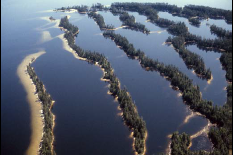
Those finger-like protrusions resemble ripples on the edge of a spring sandbar. You paddle into a maze of branching channels like interconnected puzzle pieces. It is different from the air than at water level, you can see a pattern from the aerial view. They look like elongated sand dunes surrounded by water. We need to find out about this.
You most likely are on your way to visit Maple Mountain the highest vertical rise in Ontario (not the highest peak) within Lady Evelyn-Smoothwater Provincial Park, it is a spectacular wilderness park with some roadless areas. The Lady Evelyn River is the centrepiece of the park, surrounded by some of the highest points in Ontario, with stands of towering pine and numerous waterfalls.
It is difficult to comprehend that a massive sheet of ice covered millions of square kilometres, including most of Canada and a large portion of the northern United States, multiple times during various epochs from approximately 2.5 million years ago to the present.
The last advance covered most of northern North America between approximately 95,000 and 20,000 years before the present day, and among other geomorphological effects, gouged out the five Great Lakes and the hosts of smaller lakes we have come to enjoy in all four seasons. The glaciers moved because pressure from the weight of the overlying ice caused it to deform and flow. Meltwater at the bottom of the glacier helped it to glide over the landscape creating distinct features.
Conservation Reserve Protection
In a previous interview the late Kevin Pinkerton, the Ontario Parks Superintendent for this area said “Special areas like this become protected through process.”
He said, “There are 34 conservation reserves (CR) within the North Bay District. The MNRF is responsible for managing the CRs in-line with approved management direction.
The East Lady Evelyn Conservation Reserve (ELECR) is one of eight conservation reserves and five Provincial Parks covering 104,248 hectares of protected area in the western portion of Temagami. The conservation reserves in this area complement the provincial parks in protecting representative life and earth science features as well as special landscapes.”
The area was first proposed as a CR through development of the Temagami Land Use Plan (1997). It was regulated in 2001 under the Public Lands Act and is now regulated under the Provincial Parks and Conservation Reserves Act (PPCRA) with the creation of the PPCRA in 2006. The ELECR is identified as one of the Milestones in Environmental Preservation from 1999-2007.
The Resource Management Plan completed in June of 2007, noted that recreational use was negatively affecting the dunes through vegetation loss and increased erosion. In order to mitigate the effects of recreational use going forward and preserve the integrity of the dune complex, all overnight camping within the dune complex is prohibited.
What Happened
David Webster is a Senior Conservation Geologist within the Protected Areas Section, Natural Resources Conservation Policy Branch, MNRF.
“The dunes here are spectacular and are deservedly preserved," he said. "Through interpretation they have shown us the sequence of events that occurred thousands of years ago and left us with a unique landscape to appreciate.”
He said as the LIS (Laurentide Ice Sheet) retreated from the area where Lady Evelyn Lake now is located, numerous features were left behind including eskers and outwash plains.
“The eskers were deposited by flowing water beneath the ice sheet in a “river-like” pattern,” he said. “The significance of this is that the alignment of the eskers shows us which way the water beneath the glacier was flowing and gives us an idea of the processes at work and the pattern of disintegration of the ice sheet. The presence of kettles and kames shows us where stagnant ice conditions occurred (that is how kettles are formed) and again lets us know how the glacier retreated.
“The stunning dunes are formed by aeolian forces that were at work after the glacier had retreated. When the glacier melted, outwash (melting glacial water deposited sands and gravels at the edge of the glacier) were deposited. The wind forces (aeolian) worked on these exposed sand and gravel deposits and formed them into dunes by sorting and depositing the sand (leaving behind the gravel) into morphological shapes called sand dunes. A significant part is that this must have happened prior to vegetation re-habitation of the area as the vegetation would have held the material in place.” These features give us clues as to the timing of the generation of these landforms and an insight into how the entire morphological system fits together. The dunes were eventually vegetated to stabilize them into their current form and the flooding of the lake by the development of the dam (1916) accentuated the dunes into a unique environment.”
Look at the Map
The ELECR is located approximately 17 km west of Haileybury. Drive west on Hwy. 558, from Hwy. 11 to the Mowat Landing boat launch. Then boat shuttle or portage over the Mattawapika Dam. (Call Mitichell’s Lady Evelyn Camp for a lift over, Lady Evelyn Lift Services, 705-679-8665 or 705-676-2116 – winter number). It is then a 14 km to the esker-dune complex (WGS 84 17 T E 568000 N 5248570 or N47°23.223’ W80°05.942’ ). If you canoe or kayak into this landform, you will most certainly get turned around and find yourself looking for a way from this back water to the nearest back road.