Road construction season is on. While waiting in line for the flag person to eventually give the stopped traffic the go-ahead with the fluorescent SLOW sign, waving back and forth. These are called traffic control paddles.
The Romans invented concrete (opus caementicium) and were great road and bridge builders. Roman concrete, like any concrete, consists of an aggregate and hydraulic mortar – a binder mixed with water that hardens over time.
The aggregate varied and included pieces of rock, ceramic tile, and brick rubble from the remains of previously demolished buildings. Reinforcing elements, such as steel rebar, were not used.
There remain a number of heritage bridges from the beginning of what we know now as our Trans Canada Highway. These are sometimes seen overgrown and lost in time as we speed by and utter: “there’s an old bridge!”
Use the delay, when stopped and waiting during this highway construction season to reflect on the new and old concrete bridges and why jobs are important. The Ontario government’s Northern Highways Program will invest $624 million to repair highways and bridges in the north creating or sustaining hundreds of direct and indirect jobs. These programs sustain Ontario's transportation network while strengthening the economy. Often, government program signs can be found by road and bridge construction sites, (tax dollars at work) on the approach to the flag person and the STOP sign ahead.
Following World War I, discussions of a cross-continental road through Canada became vocal and construction of such a route was undertaken.
Then came the Great Depression we took a major detour. Most of us cannot relate to the time when economic activity around the world came almost to a standstill, and road construction became important.
Thousands of men were hired to construct highways in remote areas of the province from temporary camps, named Bennett Camps “after then-Prime Minister R. B. Bennett. This provided the necessary labour to open road links through vast expanses of wilderness in a relatively short period of time. Beginning in 1931, certain routes were designated as the Trans-Canada Highway. There wasn’t the same social umbrella as today. The government was forced to act and used its limited resources to create something innovative. The government addressed itself to finding work for men, as women, then, stayed at home. The unemployed wanted to work and would take anything they could get rather than go on relief. There were 37 road construction camps throughout the province.
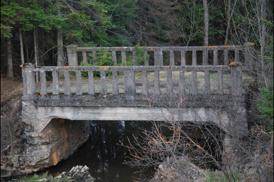
There is not much left to show of the efforts of the highway-era work camps. But one of the original bridges can be found not far from the current Trans-Canada Highway. This stately bridge is engulfed by nature as it reclaims the crumbling structure. It is located at Anderson Creek, about 4.0 km west of Desbarats and 3 km east of Hwy 548 and the turnoff to St. Joseph Island where the four lanes begin.
A Regional Issues and Media Advisor Ministry of Transportation Northeastern Region provided the following for this heritage bridge.
“The bridge is 20 feet long and 8 feet wide. It was already abandoned prior to 1967.
"Our estimate is that it was built in the 1920s and when the highway was realigned with the new culvert in the 1940s, the bridge was abandoned at that time.
"The bridge is of typical construction for bridges of that size from that era, single span rigid frame reinforced concrete beam bridge with concrete baluster railings. The bridge is of common construction which is not considered to be a heritage bridge and is not protected.
It is now situated on the land owned by the Kensington Conservancy.
“We have not done any maintenance on it other than removing some trees that were growing on it a few years ago," said Conservancy Executive Director Carter Dorscht. "Anderson Creek, especially during the spring runoff, continues to slowly erode away at the banks on either side.
“That bridge is certainly a favourite of people here and those that pass along the highway.
"We have no plans currently to do anything with the bridge. The preserve it is located on is called the Black Hole Preserve. It is a beautiful local provincially significant wetland.
“Unfortunately, The Kensington Conservancy does not have the capacity to put time and resources into the bridge, although we certainly understand the heritage and history value that the bridge brings to the community and we'd hate to lose it.
"If there was another organization or individual who was willing to potentially take the bridge on as a project, The Kensington Conservancy would certainly be open to having a conversation about that.”
Take a close look at the architecture and the width, see WGS 84 17 T E 271224 N 5135850 or N46° 20.254’ W83° 58.363’ or the map
Another good example from the past is 18 kilometres east of the Big Joe Mufferaw statue in Mattawa.
It is 1.6 km east of Klock’s Rd. and crosses Aumond Creek on the north side of Highway 17 East. It has a narrow, 14’ (4.2m) wide deck portion.
Today’s highway is 30’ (9.1m) wide [ 15’ (4.5m) from the centre to the apron]. There is an unofficial pull-off and a well-beaten trail to the bridge.
The original highway right of way is grown over by the presence of a large white pine tree.
Send me your pictures and information about any others located in cities and towns that may still exist and others still on Highways 11 and 17.
The road flag person won’t tell you about these forgotten bridges or how the Romans built the bridges to last. These bridges are memorials to when paved roads were new and cars were few. Now they are on the back roads.