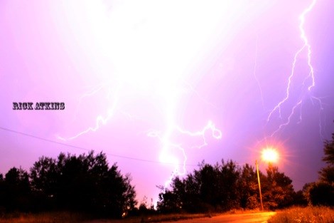
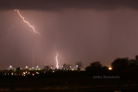
 Loyal SooToday.com readers April Bananish and Chris McKinnon went on an interesting adventure late last night and have decided to share the evidence of their adventures.
As the lightning flashed, thunder crashed and rain poured down in buckets they set up their camera gear beside the Sault Ste. Marie Canal.
After many shots they made for cover just in time to avoid the pummelling hailstones.
Unfortunately the storms travelling through Northeastern Ontario did little to abate the forest fire situation in the region.
Eight new fires started, most ignited by lightning and several of the largest fires grew significantly.
The full Northeast Region forest fire report from the Ministry of Natural Resources follows.
Current forest fire update (1900 hrs)
The Northeast Region has seen a busy day with eight new fires thus far, as well as continuous efforts on existing fires.
The largest fire at this moment is TIM 9 at 21088 hectares.
There are currently 38 actives fires in the region, burning a total of 28272.1 hectares.
The following is an update on the larger fires in the area.
Timmins 9
Timmins 9 is currently 21088 hectare in size and is north of Gogama.
There was significant growth on the fire yesterday evening, and the fire is approx. 45 km in length.
The MNR has requested that all people in areas including the west side of Kenogamissi Lake leave immediately.
No further evacuations are being considered at this time. Mattagami First Nation has not been evacuated, but are prepared to if evacuation is required.
Crews are currently assigned to this fire, and working on values protection. An Incident Management Team is also being established to assist with efforts on this fire.
With little to no precipitation expected over the next week, people are reminded to remain vigilant.
Kirkland Lake 8
Kirkland Lake 8 is currently 2757.0 hectares in size.
The town emergency response team estimates a total of 300 people were evacuated from Goldthorpe road (West side of Kirkland Lake), Goodfish Lake and other northerly lakes.
The municipality has made arragements for evacuees to stay at the Kirkland Lake Royal Canadian Legion, while some evacuees are making arrangements with family or friends.
The town of Kirkland Lake has been running radio ads with fire information and town evacuation updates.
The fire concern today was changing wind direction from the south to the north-west which would push the fire closer to town.
Efforts continued on the fire today with a birddog and waterbomber, as well as crews working on values protection.
An Incident Management Team has also been ordered to aid in efforts fighting this fire.
Wawa 4
Wawa 4 is currently 3300 hectares in size.
An incident management team is on site working with resources.
FireRanger crews continued with suppression efforts today, and looking at doing an infrared ground scan.
The fire is currently listed as Not Under Control.
Wawa 5
Wawa 5 currently 50 hectares in size.
Crews have been making good progress on the fire.
The fire is currently listed as Under Control.
Timmins 5
Timmins 5 is currently 8 hectares in size.
Crews continue with clean up on this fire, and it is currently listed as Under Control.
Timmins 7
Timmins 7 is currently 476.5 has in size.
An Incident Management Team is on site as well as crews.
Clean up on the fire continues.
The fire is currently listed as Being Held.
Kirkland Lake 5
Kirkland Lake 5 is currently 27 hectares in size.
Crews continue clean up on the, and it is currently Under Control.
Chapleau 8
Chapleau 8 is currently 195 hectares in size.
Crews continue clean up on the fire, and it is listed as Not Under Control.
North Bay 8
North Bay 8 is currently 32 hectares in size.
Crews continue clean up on this fire, and it is currently listed as Under Control.
To date, there have been 151 fires in the Northeast Region, having burnt 28549 has.
Contact Numbers:
Evacuation/road closures, Kirkland Lake Municipal Office 705-568-9365 X221
Smoke and health related questions: Telehealth Ontario 1-866-797-0000
OPP Highway Closure Information: 1-888-310-1122
Map of Current Fires in Ontario
Fire Hazard
A Restricted Fire Zone is currently in effect for the Northeast Fire Region, north of the French River including French River Provincial Park.
The restricted fire zone includes the MNR districts of Sudbury, North Bay, Sault Ste. Marie, Timmins, Kirkland Lake, Hearst, Chapleau, Wawa, Cochrane and Manitoulin Island.
No open burning, including campfires is permitted within the boundaries of a restricted fire zone.
Portable heaters or propane stoves may be used for cooking and warmth but must be handled with extreme caution.
All burning permits are suspended.
For up to date information on the current status of the Restricted Fire Zone, please call the Northeast Region Restricted Fire Information Hotline at 1-866-357-8422.
*************************