 8:15 update
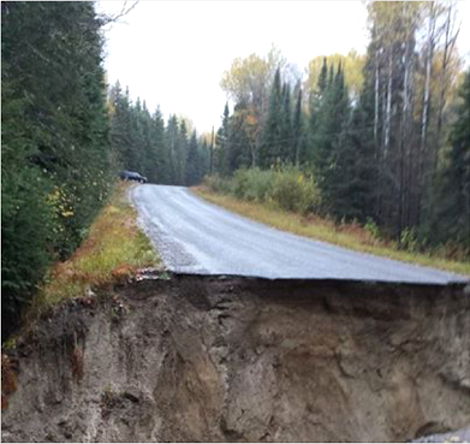
And he or she means a full-blown road-done-gone sort of washout.
Not just some little damage across the side of the road.
The picture posted (seen above) pretty much tells the story.
SooToday will have more on this as information becomes available.
According to Environment Canada a rainfall warning is still in effect for Sault Ste. Marie - St. Joseph Island - Searchmont - Montreal River Harbour - Batchawana Bay
"Rain is expected to continue into tonight, with the heaviest rain expected mainly this evening. Some areas have already reported over 50 mm of rain," says a rainfall warning updated by Environment Canada at 6:19 p.m. "Totally rainfall amounts of 50 to 70 mm are likely by later this evening."
The site goes on to warn that, "Heavy downpours can cause flash floods and water pooling on roads. Localized flooding in low-lying areas is possible."
As reported earlier today by SooToday, the city of Sault Ste. Marie is implementing flood control measures
Sault Ste. Marie Region Conservation Authority has issued a statement to residents in regard to current watershed conditions.
"If the anticipated amount of precipitation occurs there will be localized flooding in areas of poor drainage," says that statement. "The areas of poor drainage include areas of the City of Sault Ste. Marie where catch basins may be blocked."
"The amount of runoff anticipated from this rain event is expected to raise water levels significantly in the short term and rivers and streams have the potential to reach flood criteria."
Heavy rain is expected to continue in the area over night and into tomorrow.
More rain is expected, though not as heavy, until Saturday.
If you see or experience flooding in your area send photos and a brief description indicating who took the picture, when and where it was taken and a short description of what's happening in the photo to [email protected]