 NEWS RELEASES
MINISTRY OF NATURAL RESOURCES/SAULT STE MARIE REGION CONSERVATION AUTHORITY
****************************
The Sault Ste. Marie Region Conservation Authority would like to issue a statement to residents in regard to current watershed conditions.
There is a weather system tracking across northern Ontario which has the potential to bring precipitation amounts of over 50 mm with potential additional amounts in thunderstorms over a wide area.
The current weather forecast indicates that precipitation amounts of 30 - 40 mm are expected Wednesday to fall over the Sault Ste. Marie area over 24 hours with the potential of up to 50 mm.
Ground conditions are able to absorb some of these forecasted rainfall amounts.
The local streams and rivers in our watersheds are currently flowing at below seasonal levels and have the capacity to accept precipitation and runoff from the anticipated rainfall amounts.
The current watershed conditions differ greatly from last year’s flood event.
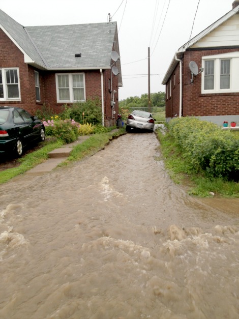
If the predicted thunderstorms occur there may be localized flooding in areas of poor drainage.
The areas of poor drainage include areas of the City of Sault Ste. Marie where catch basins may be blocked.
The amount of runoff anticipated from this rain event is expected to raise water levels significantly in the short term and rivers and streams have a slight potential to reach flood criteria.
The flood control channels owned and maintained by the Sault Ste. Marie Region Conservation Authority are currently flowing well below normal. The flood control channels will experience a rise in water levels. It is important to remember that the water in rivers, streams and the channels will be fast flowing during and after the rainfall event.
The Sault Ste. Marie Region Conservation Authority will continue to closely monitor stream flows across the watershed.
The Sault Ste. Marie Region Conservation Authority would like to extend a warning to residents and visitors to use extreme caution when close to rivers, creeks and channels. Potential increases in water levels and flows can be especially dangerous and stream banks can be slippery. Please keep children and pets away from fast flowing rivers and streams.
This bulletin will be updated if conditions warrant.
****************************
The Ministry of Natural Resources – Sault Ste. Marie District is advising area residents that a Watershed Conditions Statement - Flood Outlook is in effect in the District.
Residents should keep a close watch on conditions, regularly check for updated messages and stay away from fast-moving rivers and streams.
MNR is closely monitoring the weather and developing watershed conditions. Further updates will be issued as appropriate.
Description of Weather System
On Wednesday, September 10, a Colorado Low is forecast to track northeastward across the Province pushing significant amounts of precipitation across a wide swath of Northeastern Ontario through the afternoon and into the evening.
Although there is still some uncertainty in the exact track of the low, general rainfall amounts in the 30 to 60 mm range are expected for portions of Northeastern Ontario and areas north of Superior.
Rain could be heavy at times and higher amounts may be possible locally, particularly for areas where thunderstorms occur.
Meanwhile, Southern Ontario is forecast to receive 25-35mm of rainfall during the 24 hour period.
On Thursday September 11th, the low is forecast to move out of the Province and into Quebec then a ridge of high pressure is forecast to build in on Friday clearing skies for most of the region.
Description of Current Conditions
Stream flows are at or near seasonal values across most of the District, however, the heavy rainfall forecasted over the next few days could overwhelm local drainage systems, and localized flooding may occur.
A close watch on local forecasts and conditions is recommended.
This message will be in effect until (or updated before) Thursday, September 11, 5 p.m.
Terminology: Notification Levels
WATERSHED CONDITIONS STATEMENT - FLOOD OUTLOOK: gives early notice of the potential for flooding based on weather forecasts calling for heavy rain, snow melt, high winds or other conditions
WATERSHED CONDITIONS STATEMENT – WATER SAFETY: indicates that high flows, melting ice or other factors could be dangerous for such users as boaters, anglers and swimmers but flooding is not expected.
FLOOD WATCH: potential for flooding exists within specific watercourses and municipalities
FLOOD WARNING: flooding is imminent or occurring within specific watercourses and municipalities.
A close watch on local conditions and weather forecasts from Environment Canada is recommended.
Environment Canada bulletins can be found at http://weather.gc.ca/
The Surface Water Monitoring Centre public webpage can be found here.
****************************