"There is a significant amount of city-owned vacant land that could be repurposed for providing recreational amenities for the James Street neighbourhood," the report states.
"The large green space at the corner of West and Cathcart streets was originally created during the 1970s urban renewal projects through clearance of homes in the Cathcart-West-Rome Street-May Lane area, but has sat vacant ever since."
"This underutilized space could be used for some relatively low-cost recreation installations that might not be commonly found across the city, especially in the Sault’s core areas."
Possible uses for the West Street green space identified in the draft strategy include:
- berms or mounds that could function as a tobogganing hill and sitting space
- small dirt-surface bike track
- small soccer field with goalposts
- benches and picnic tables around existing mature trees
The report also discusses linking the West Street green space to James Street, and employing colourful painting or landscaping on the existing parking lot to make a contiguous public space.
More than one year in the making, the document points out that Jamestown has extraordinarily low rates of participation in organized sports and membership clubs.
"Data received from various sports and recreation organizations in Sault Ste. Marie – including the YMCA, Sault Youth Soccer, CanSkate and Sault Minor Football – indicate that very few residents from the James Street neighbourhood are registered in organized sports and other recreational programs."
"Given the low participation rates in organized sports and recreation, additional opportunities should be explored to provide informal or less-structured activities that allow a range of athletic and recreational play within the neighbourhood."
The strategy document also proposes to changes to Anna Marinelli Park.
"The current Anna Marinelli Park consists of approximately 1,200 square metres. It is a quarter of the size of the original Anna Marinelli Park that was located just east of the CP rail tracks between Albert Street West and Queen Street West beside the former St. Mary's elementary school."
"The former park included a playground, baseball diamond and tennis court. It was relocated in 2005 to its current location at the corner of James and Albert in order to accommodate the construction of Carmen's Way. In addition to its reduced size, there is currently no space or equipment for sports or athletic forms of recreation."
Ideas for Anna Marinelli include:
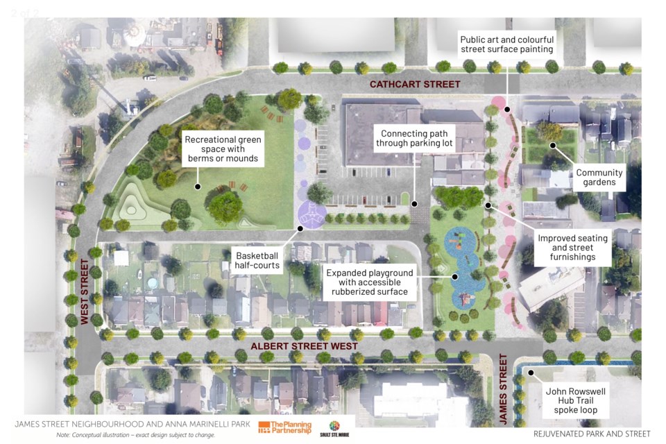
- resurface Anna Marinelli Park using a rubberized, accessible surface (members of the city's parks and recreation advisory committee were advised last week that this work is already underway)
- add playground equipment for a range of ages and abilities
- make the street more welcoming by refurbishing existing street furniture, benches and planters
- remove concrete blocks at the north end of James Street
- start a community garden program at the Soup Kitchen Community Centre
- use public art and celebratory plaques to enliven the James Street public realm and narrate the neighbourhood's unique history
- consider expanding Anna Marinelli Park onto the existing unpaved parking lot abutting the park, in front of the Soup Kitchen
- activate James Street through programming
- consider replacement of existing large street furniture with more modular and contemporary furnishings
The draft strategy will be presented to City Council on Oct. 26.
A window display of the strategy has been set up for public viewing beside the front entrance of the Soup Kitchen Community Centre at 172 James St.
It can also be viewed online.
Other suggestions include:
- construct a pedestrian crossing facility at the intersection of Carmen's Way and Albert Street West, similar to the new crossing at Wellington Street West and Beverley Street
- extend the John Rowswell Hub Trail system into the James Street neighbourhood, via a spoke trail loop. This could be done with a new multi-use path along Albert Street West, James Street, Queen Street West, George Street and then connecting back to the existing Hub Trail at Huron Street
- undertake an analysis to determine appropriate improvements to better facilitate pedestrian and cyclist crossings at Carmen's Way at Cathcart Street, Carmen's Way at Queen Street, Queen Street at James Street, Albert Street at Huron Street (by Greco Pool and Captain Nichola Goddard Park)
- explore creation of more visible and intuitive pedestrian connections to the Steelton neighbourhood along the existing Hub Trail north of Cathcart Street
- work with Canadian Pacific Railway (CP) to clean up and transform the former railway right-of-way on the west side of Carmen's Way into a more welcoming landscaped area
- reach out to city-wide health and social services agencies to explore the possibility of establishing a 'wellness centre' in or within walking distance of the James Street. Garden River Wellness Centre is proposed as a model for this
The strategy document points out that only three retail businesses remain in a neighbourhood that once had a healthy business district – Spadoni's Furniture, Mathewson Office Pro and Pristine Auto Detailing.
It proposes changing the official plan designation of lands along the north side of Cathcart Street and the west side of West Street to permit a mix of light industrial and commercial uses.Another suggestion is to use the Sault's economic growth grant program to attract export-based industries on vacant land in the neighbourhood.
The city report cites the 2018 CTV/Vice Media documentary Steel Town Down as evidence that the neighbourhood has gained a reputation as "a place that needs help."
The draft strategy document includes many other interesting bits of background and perspective, including the following observations:
"The James Street neighbourhood is located in the original west end of the City of Sault Ste. Marie, and has been known by different names over the years, such as 'Jamestown,' 'Little Italy' and the 'West End' It is surrounded on three sides by Algoma Central Railway and Algoma Steel. There isn't a precise definition as to where the neighbourhood's easterly boundary lies. Some consider Carmen's Way as the neighbourhood's easterly boundary, while others who live as far as Huron Street also consider themselves residents of this neighbourhood."
"This is one of the most storied neighbourhoods in Sault Ste. Marie, especially to European immigrants who came to the city in the early 20th Century and chose to settle here. It was known as a lively community of immigrants, including Italians, Ukrainians, Croatians and others. Residents often remember it as a neighbourhood where one could easily get everything a household needed. A survey in 1960 counted almost 2,000 rsidents living between the steel plant and the Canadian Pacific (CP) rail tracks. A local neighbourhood organization at that time, the West End Ratepayers Association – also known as the West Street to Huron Street Ratepayers Association – consisted of 600 members."
"Today, 60 years later, Statistics Canada’s census data show that approximately 850 people live in the area between Cathcart Street to the north, West Street to the west, the Algoma Central Railway to the south, and Hudson and Toronto streets to the east. Of the residents in the neighbourhood, 56 per cent live in apartment buildings, and almost three-quarters rent rather than own their home. Over the decades, the neighbourhood has gained a reputation as a place that needs help. In 2019, the average residential property assessment value per dwelling unit was around $60,000 in the James Street neighbourhood, compared to $166,000 city-wide."
"Despite some of the perceptions of this neighbourhood, there is optimism that this neighbourhood can be rejuvenated. Many of the people who still live, work and volunteer in this area are very passionate and engaged about their neighbourhood. In addition, the James Street neighbourhood already has some of the key components of a ‘complete neighbourhood’: it’s a neighbourhood where generations of families can live within close proximity to one another; a neighbourhood that provides a diverse range of housing options; a neighbourhood that has (although underutilized) a tremendous amount of public space; and, a mix of land uses with the potential to provide goods, services and employment opportunities all within walking distance."
"The block of James Street between Albert and Cathcart forms the social heart of the neighbourhood. The Soup Kitchen Community Centre on James Street is a regular hub for community activity and social gathering, and Anna Marinelli Park at the corner of James and Albert is currently the only place within the neighbourhood for families to go for outdoor play and recreation."
"Despite being termed a 'pedestrian mall,' it is clear from planning staff's observations that the current state of James Street does not work in terms of being a vibrant and attractive place for people to visit and stay. Planning staff heard that residents are troubled by potential needles in the playground, public drinking and drug activity, and general safety concerns. While the Soup Kitchen is a bustling hub of activity, James Street, just outside its doors, is often deserted and a completely different picture."
"Anna Marinelli Park currently contains a playground with a swing set for toddlers, and a play structure and another swing set for grade-school children. However, residents have indicated that they wish to see a greater variety of play offered at the park, especially for toddlers and older youth. Another suggestion was that the park could be improved by adding more seating for families and older adults – more places to sit and relax would help foster parent-child engagement as well as neighbourhood socialization."
"The James Street neighbourhood falls into the category of most ‘materially deprived,' according to the 2016 Ontario Marginalization Index. This means there is a very high proportion of residents and households in this neighbourhood who are unable to afford typical consumer goods and services. Based on the 2016 Census, 53 per cent of residents in the James Street neighbourhood are considered low-income, including 68 per cent of children aged 0 to 17 years. In contrast, across Sault Ste. Marie, 16 per cent of all residents and 22 per cent of children aged 0 to 17 years are considered low-income. Furthermore, 39 per cent of the families who live in the James Street neighbourhood are lone-parent families, compared to 20 per cent across the city."
"The James Street neighbourhood is one of the 'hotspots' in the city with higher incidence of confirmed opioid overdoses. In addition, as mentioned previously, the James Street neighbourhood is considered a highly materially deprived neighbourhood. Residents in such neighbourhoods generally experience over two times the rate of cardiovascular disease, five times the rate of mental health emergency department visits, 2.8 times the rate of youth self-harm emergency department visits and over three times the rate of potentially avoidable deaths, compared to residents in least deprived neighbourhoods."
"James Street is a stigmatized neighbourhood, and community members believe this stigma may be partially attributable to the physical appearance of the neighbourhood, particularly its entrance along Carmen's Way. The Canadian Pacific Railway lands beside Carmen's Way have been vacant since the rail line was decommissioned, and is now little more than unsightly bush. Working with corporate and community partners to transform the CP lands into an attractive and enjoyable neighbourhood edge can shed new light onto the James Street neighbourhood and create a more positive impression for this area."
"James Street is a neighbourhood that has experienced upheaval multiple times throughout the last 60 years – from the demolition of the Highline in 1958, to the development and redevelopment of the International Bridge Plaza, the urban renewal projects of the 1970s and the construction of Carmen's Way in the early 2000s.The 2016 census indicates that the James Street neighbourhood is home to a higher proportion of new and transient residents than Sault Ste. Marie as a whole – 21 per cent of residents in the neighbourhood moved to the city only within the past five years, whereas in comparison, eight per cent of residents city-wide are newcomers to the Sault.
"Both census data and community stakeholders indicate that people who relocate to Sault Ste. Marie from other cities in Ontario often choose the James Street neighbourhood for their first home, perhaps due to the availability of affordable rental housing. Yet, these new residents frequently leave for other neighbourhoods after a short time. Recently, community members have noticed an influx of international students choosing to live in the James Street neighbourhood while studying at local post-secondary schools."
"Despite its shortcomings, this neighbourhood still has its advantages and appeal. If the recommendations in this James Street Neighbourhood Strategy are implemented, James Street can be transformed into a model of a positive, complete neighbourhood, bringing tangible social, cultural and economic benefits for both the James Street neighbourhood and all of Sault Ste. Marie."