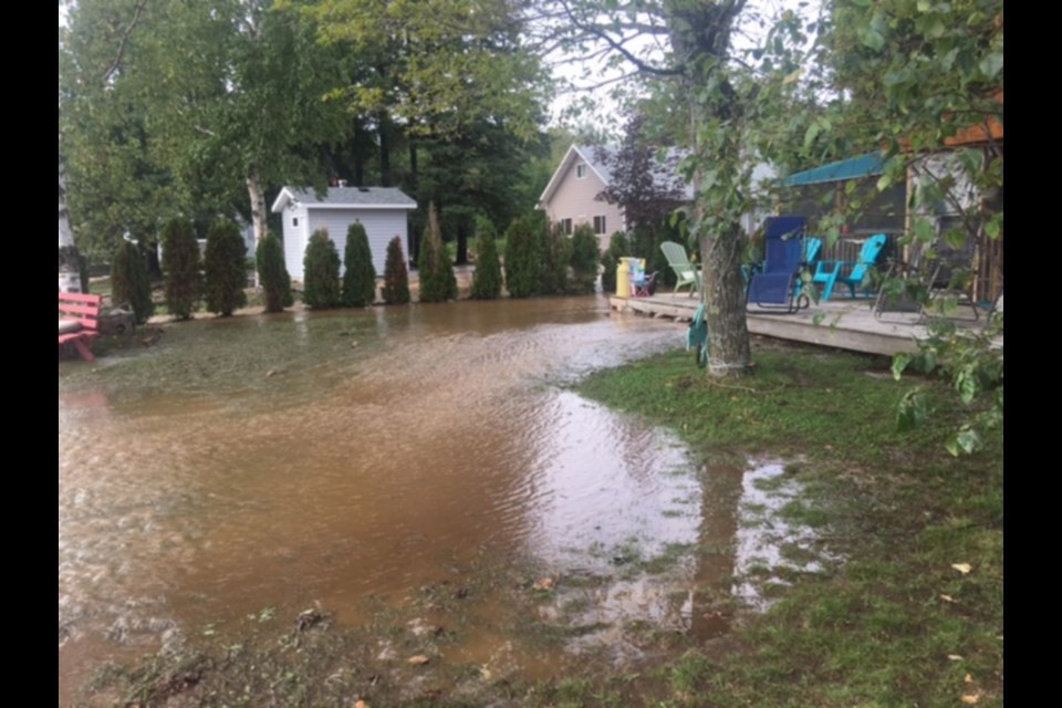
While flooding in Goulais River is not unusual, a dozen property owners in the Wally’s Lane area of the community are experiencing exceptionally heavy flooding due to a creek overflow.
Josie Facca, a Sault native who lives and works in the Toronto area but maintains a summer residence in Goulais, described it as “frustration.”
Facca, speaking to SooToday in a telephone interview Wednesday, said problems on Wally’s Lane began to manifest themselves starting with a Sept. 5 road washout on Highway 17 north between Harmony Beach and Wawa, which closed the highway in both directions.
The flooding on Wally’s Lane has continued with subsequent heavy rains Thursday, Oct. 4 and Tuesday, Oct. 9, Facca said.
“All this debris, like cement and rocks and lots of sand, came down on our property from somewhere.”
Facca said she and other Wally’s Lane property owners “definitely” believe the problem stems from Ministry of Transportation of Ontario (MTO) summer 2018 roadwork on Highway 17.
“Yes, there are beaver dams breaking and significant rainfall, but if you have the infrastructure that can handle the creek, like it did for 50 years (there should be no flooding)."
Facca said the group of property owners has hired a contractor to dig ditches around their properties to protect them from further damage.
“We have to go hire engineers and go after the Ministry of Transportation because obviously they took shortcuts in the design of the culverts and water flows when they were doing the Highway 17 work...and the Ministry of Transportation is telling us to go to the Ministry of Natural Resources.”
“The Ministry of Natural Resources, who we’ve been working with for the past month or so, more or less say ‘a beaver dam broke, this happens all the time.’”
“The MNR more or less told us that they’re there to issue permits for work on the main waterways and that’s it, that this is the homeowners responsibility and problem.”
Meanwhile, Facca said “it’s become a river flowing between my house and my neighbour’s. It’s like a brand new river that wasn’t there before,” adding fellow property owners have suffered damage “to varying degrees.”
Facca said on top of employing people to hold the water back, the group is looking at speaking to lawyers to get action on the matter, praising Algoma-Manitoulin MPP Michael Mantha for his efforts to get the government to respond.
Facca said Mantha was scheduled to visit the area in person Thursday evening.
“We’ve just kind of banded together, the whole group of us, to say ‘enough is enough,’ we’ve given these guys so many chances to make it right.”
“I got three inches of water in my cottage and had to rip out my hardwood floors...I’ve got a lot of damage and my insurance won’t cover it (though the MNR has issued a partial dredging permit for the area),” said Gary DeBoer, Facca’s neighbour.
“I know there’s a tremendous amount of rain, and there was a beaver dam that broke...but that fill came from somewhere.”
While not certain, DeBoer said “It’s my feeling (MTO roadwork on Highway 17 caused the problem).”
“I’ve been there 15 years and it’s never, ever happened like this. Guys have been there for 40 years and it’s never done that...it’s come down to us hiring an engineer to see how we can change the flow and stop it from destroying our properties,” DeBoer said, adding residents feel they’re being bounced back and forth between the MNR and MTO.
“I would like to see us be permitted to dredge the whole creek and use the fill to berm up the creek on both sides. They said that would be a band-aid solution but sometimes band-aids heal wounds,” DeBoer said.
Bill May, Ministry of Natural Resources and Forestry (MNRF) Sault Ste Marie District resource management supervisor, in an email response to SooToday Thursday, wrote “the ministry does not support further dredging in the river.”
Acknowledging the Sault Ste. Marie district received heavy rainfall Sept. 5 that impacted many areas and residents, including residents along Goulais River’s Wally’s Lane and the adjacent Downey Creek, May wrote “the Ministry of Natural Resources and Forestry responded by issuing a work permit to one individual landowner, who is acting on behalf of other adjacent landowners, that allowed a portion of the creek near the mouth of the river to be dredged.”
“This dredging facilitated the movement of water away from the properties. Landowners were made aware that this is a short-term solution, and that they should seek technical advice from an engineering firm capable of assessing the issues and providing sound solutions,” May wrote.
“Landowners may do work on their own private property to help mitigate flooding, such as sandbagging or ditching to protect structures as long as the work is not connected to, or in the creek system or adjacent shoreline,” May added.
In a subsequent email to SooToday Thursday, Facca wrote “their (MNRF) recommendation is to let nature take its course and not dredge. I vehemently disagree with this assessment. I’m not sure how nature can take its course when there is a solid riverbed of rock, cement and sediment of an unknown source and it cannot flow. My logic tells me clear this, and then let nature take its course when the stream has been opened…(we need) a longer term solution the MNRF should be assessing, not us.”
SooToday had not received comment from MTO officials when this story was published.