There is a Stonehenge in Northern Ontario.
Myth or belief, maybe it is like the Loch Ness monster? You see what you want to see; you think what you want to think.
What’s more fun than a mystery where you can write the ending? On a back road near a unique shoreline is a configuration of huge boulders that pose more questions than answers.
The unusual aggregation of these rounded rocks may not have the same visual impact as Stonehenge, the prehistoric monument on the Salsbury Plain in England.
No one seems to be sure how these huge, rounded rocks arrived and when? Why does the alignment match exactly with the rising and setting of the sun on the winter and summer solstices? One person has spent a lifetime trying to discover the significance. Why do Indigenous people consider this a sacred site - is it the proximity to a nearby mountain top, a retreat for shamans?
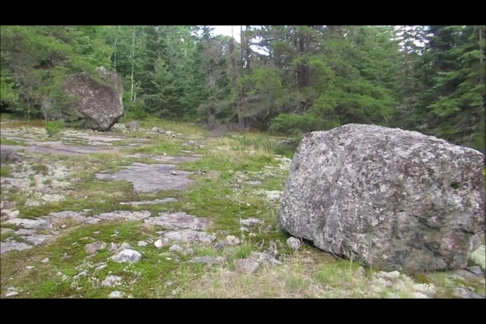
There is an aggregation of 18 huge erratics, some twice the height of a human on the shores of Larder Lake, east of Kirkland Lake.
Like members of a small community, these “Stonehenge” rocks are well known to the residents of Larder Lake, situated across the water body of the same name on the northeast shore near the Big Narrows.
A glacial erratic is a piece of rock that differs from the size and type of rock native to the area in which it rests. The erratics here are dissimilar; many of them have different origins and compositions. Another question has been posed by researchers; could it be possible the rocks were stacked on top of one another and have now fallen over?
The site is found on a flat almost barren stretch of bedrock, much different than the surrounding terrain. There are striations everywhere etched into the rock. These are the lines or scratches on the surface inscribed by rock fragments embedded in the base of a glacier as it moved across.
When you come to the boulders the immediate difference is noted when compared to the surrounding terrain. That in itself is a geological anomaly. The four-stone alignment matches exactly with the rising and settings of the sun on the summer and winter solstices. Can these rock’s proximity to nearby Mt. Cheminis, a solitary and significant height of land be simply a coincidence?
Conundrum?
Vernon Dufresne did not think so. He lived most of his life in the Larder Lake area he said the rocks has been a “conundrum” for him for years. In a previous interview, he thinks the rocks were moved into place for a reason.
In the year 2000, he released his study and interpretation of the site.
“The Rock Structure is very unique. There is no other similar site in North or South America. It may be compared to medicine wheels found in the Canadian and American prairies,” Dufresne wrote.
His investigation points to the configuration of four large rocks aligned in a north-south direction in line with Polaris, the North Star. He believes some of the rocks could have been moved to form this significant directional monument for early Indigenous peoples and their seasonal relationships with the land.
“It has been fun,” he said. “People look at me with bewilderment or appreciate the science behind the theory.”
There is little to no soil on the flat bedrock in the immediate area of the boulder field with a lack of boulders on the shoreline when compared to the adjacent shorelines.
Geologists have made note of this peculiarity. One Ministry of Northern Development and Mines report states, “The edges of the cleared area looked unnatural as well, as though the overburden and boulders had been pushed away.”
An ethnological investigation became part of an archaeological study of the Larder Lake “Mystery Rocks” in 1992. A Native elder and shaman, Fred Pine, was brought to the site by archaeologists.
From the report of archaeologist Thor Conway, “Fred definitely thought that the mystery rocks of Pearl Beach were used for such purposes by prehistoric peoples. He feels there is a power in the rocks underneath the site which he could feel by walking there. He thought the area had been previously cleared.”
Dolstones or rock alignments were used by early Indigenous peoples as “power snares” to capture spirits which then could be used against their enemies. A location such as this was known as a “power spot.”
Within 300 metres there is a significant Indigenous encampment.
Archaeologist Dr. John Pollock discovered the adjacent beach (Pearl Beach) had been used extensively as a home by Indigenous people from the earliest post-glacial times (6,000 B.C.) up to the historical present. In fact, 14 other sites have been identified on Larder Lake.
Dr. Jonathan Pitt thinks this is a spiritual site. His family is comprised of Ojibway and Algonquin First Nations, his heritage also includes Huron and Cree ancestry. He is currently a part-time instructor in Nipissing University's Schulich School of Education Aboriginal Education Programs and a full-time school teacher with the Near North District School Board.
“We know that our medicine people could communicate at sacred rock sites in ways that modern science cannot comprehend; as it is generally understood communicating on another plane of existence that I have often heard referred to as ‘Spiritual Smartphone.’ Our Grandfather Rocks, we understand that they have been here longer than us, (i.e. The Big Bang Theory) and have seen more and experienced more than our physical bodies can endure.
"They have what is commonly understood as a memory of the earth’s past.
There are relationships between these sacred rocks, our rituals, dreams, visions, pictographs and the constellations. Because so much of our knowledge has been lost, my sense is that perhaps our ancestors had a greater understanding of the night sky than we do today.
"Rocks and formations with features that might resemble an obelisk or have unique tall features may have been used for ceremony (vision/cleansing) or to communicate with the spirit world.
The composition or type of the rocks themselves at sites might also have been a factor in site selection and are just a few examples at sites we know of that have been used since time immemorial,” Pitt said.
The site was featured in Ron Brown’s book, 50 Unusual Things to See in Ontario.
“I was first guided to this "Stonehenge" site in the mid-1980s.
"I met with a local surveyor who took me to the location; he explained the configuration to me based on his mapping, and their apparent relation to the solstices.
"There also is apparently evidence of a First Nations quarry on the shores of the lake, and that nearby Raven Mountain, which looks like a volcanic plug, was a religious focus of some description. I have also been told that the site lies on what may have been an early Indigenous transportation route to James Bay,” wrote Brown.
Cheminis Mountain, also called Mount Chadron, can be seen, in the distance, from the shoreline. More on this within a previous Back Roads Bill story.
It would have been like a ‘signpost‘ in the wilderness. The early Ojibway held this mountain in great spiritual reverence. They called the hill ‘Shewmeness’. The Ojibway shamans were known to occasionally retire to the summit of Shewmeness to fast and meditate. The hike to the top is worth it and after you visit the Stonehenge of Northern Ontario, here is the map.
In mysteries, there are puzzle pieces to connect. Whatever you want to believe about this anomaly is for you to solve within your own sense of what is or isn’t on the back roads.