SPECIAL WEATHER STATEMENT
ENVIRONMENT CANADA
***************************
Snow squall watch issued for:
Sault Ste. Marie - Superior East - Elliot Lake - Ranger Lake - Manitoulin - Blind River - Killarney
An Arctic cold front will sweep through northeastern Ontario this afternoon into this evening.
This front has the potential to generate a snow squall as it moves through.
Latest indications suggest the cold front and snow squall will sweep across the Kapuskasing, Timmins and Chapleau to Sault Ste. Marie areas this afternoon, and will reach the Manitoulin, Kirkland Lake, Sudbury and North Bay areas this evening.
Along this cold front, a band of heavy snow is expected to develop.
Many areas may receive a quick 2 to 4 cm of snow as is moves through.
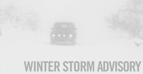
Visibility will be briefly reduced to near zero due to heavy snow and blowing snow as the cold front and snow squall move through.
Motorists should be prepared for a sudden deterioration in driving conditions.
Travel may be hazardous due to sudden changes in the weather.
Visibility may be suddenly reduced at times in heavy snow.
Snow Squall Watches are issued when conditions are favourable for the formation of bands of snow that could produce intense accumulating snow or near zero visibilities.
Environment Canada meteorologists will update alerts as required, so stay tuned to your local media or Weatheradio.
Email reports of severe weather to [email protected] or tweet with the hashtag #ONStorm.
***************************