3:36 a.m.update
Wind warning for Sault Ste. Marie, St. Joseph Island, Searchmont, Montreal River Harbour, Batchawana Bay, Ranger Lake, Elliot Lake continued.
Winds of 60 gusting to 90 km/h or above are expected.
Persons in or near this area should be on the lookout for adverse weather conditions and take necessary safety precautions.
Rainfall warning for Sault Ste. Marie, St. Joseph Island, Wawa, Searchmont, Montreal River Harbour, Batchawana Bay, Blind River, Thessalon, Ranger Lake, Elliot Lake ended.
2:30 a.m. update
Current Conditions: Winds out of the west at 57km/h, gusting to 86km/h.
Current Temp: 5 degrees (feels like -1).
Wind warning remains in effect.
Rainfall warning remains in effect.
Viewers have reported power outages in the Brule Road, Awares Township and Fourth Line East areas.
In the late morning.rain showers are expected to change to periods of snow. (2 to 4 cm expected).
Wind will shift slightly to northwest at a steady 50 km/h, gusting to 90km/h.
The temperature is expected to fall to -3 by Monday afternoon.
***************************
Issued 9:07 p.m. - Wind warning for Sault Ste. Marie - St. Joseph Island - Searchmont - Montreal River Harbour - Batchawana Bay - Manitoulin Island - Espanola - Killarney - Blind River - Thessalon - Greater Sudbury and vicinity - Elliot Lake - Ranger Lake
Significant winds tonight and Monday morning.
Strong westerly winds associated with an intense low pressure system from Colorado will develop tonight into Monday morning.
Winds of 60 gusting to 90 km/h or above are expected.
An intense low pressure system from Colorado is over Sault Ste. Marie area and will continue on to Moosonee overnight.
This system is expected to bring significant snowfall to parts of Northwestern Ontario and significant rainfall and strong winds to parts of Northeastern Ontario.
The weather system will move into Northwestern Quebec on Monday.
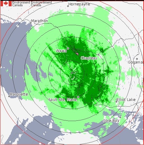
Rainfall warning for Sault Ste. Marie - St. Joseph Island - Searchmont - Montreal River Harbour - Batchawana Bay - Agawa - Lake Superior Park - Wawa - Pukaskwa Park - White River - Dubreuilville - Manitoulin Island - Espanola - Killarney - Blind River - Thessalon - Greater Sudbury and vicinity - Elliot Lake - Ranger Lake
Near 50 mm of rain in many areas by tonight.
Rain at times heavy in advance of an approaching low pressure system will continue to soak the regions from Lake Superior east to the Manitoulin Island area tonight.
Total rainfall amounts of 50 mm are expected in many areas.
Embedded thunderstorms are possible and could give locally higher amounts.
Heavy rain is expected to taper off to a few showers or flurries tonight as the low tracks into Northwestern Quebec.
***************************
Significant winds tonight and Monday morning.
Strong westerly winds associated with an intense low pressure system from Colorado will develop tonight into Monday morning.
Winds of 60 gusting to 90 km/h or above are expected.
An intense low pressure system from Colorado is over Sault Ste. Marie area and will continue on to Moosonee overnight.
This system is expected to bring significant snowfall to parts of Northwestern Ontario and significant rainfall and strong winds to parts of Northeastern Ontario.
The weather system will move into Northwestern Quebec on Monday.
Rainfall warning for Sault Ste. Marie - St. Joseph Island - Searchmont - Montreal River Harbour - Batchawana Bay - Agawa - Lake Superior Park - Wawa - Pukaskwa Park - White River - Dubreuilville - Manitoulin Island - Espanola - Killarney - Blind River - Thessalon - Greater Sudbury and vicinity - Elliot Lake - Ranger Lake
Near 50 mm of rain in many areas by tonight.
Rain at times heavy in advance of an approaching low pressure system will continue to soak the regions from Lake Superior east to the Manitoulin Island area tonight.
Total rainfall amounts of 50 mm are expected in many areas.
Embedded thunderstorms are possible and could give locally higher amounts.
Heavy rain is expected to taper off to a few showers or flurries tonight as the low tracks into Northwestern Quebec.
***************************